Abstract
This article introduces an ongoing Digital Humanities project aimed at leveraging the
benefits of Natural Language Processing, Corpus Linguistics, Machine Learning, and
Spatial Analysis for advancing the computational analysis of vast historical corpora.
As a case study, the project concentrates on the Relaciones
Geográficas de la Nueva España (1577–1585), one of the key corpora for
understanding the early colonial period of Mexico.
Using a computer–assisted methodology called Geographical Text Analysis (GTA), the
project offers automatic means for parsing historical texts and the markup of words
referring both to place names (toponyms) and analytical concepts that are then linked
to their geographic locations. Adding geospatial intelligence to the parsing of texts
allows exploring hidden geographies and narratives in the historic corpus. The
article provides a general overview of the corpus, describes the GTA methodology step
by step, and reports on the progress achieved so far.
1. Introduction
This article introduces the project
Digging into Early Colonial
Mexico: A Large–Scale Computational Analysis of Sixteenth–Century Historical
Sources, and describes the progress achieved so far.
[1] The project focuses on
developing novel methods and tools for mining new knowledge from textual and
pictorial historical records to facilitate the study of early Latin American history.
It concentrates on one of the most important corpora related to the geography,
culture, religion, economy, and history of native and Spanish peoples in Mexico and
Guatemala, namely the
Relaciones Geográficas de la Nueva
España (Geographic Reports from New Spain), and specifically those
compiled between 1577 and 1585, hereafter referred to as RGs.
The proposed methodology — called Geographical Text Analysis (GTA) — enables the
automatic markup of words referring both to place names (toponyms) and analytical
concepts relevant to historical research, and adds geospatial intelligence to the
parsing of texts. This process is useful not only to find the most salient terms in
textual corpora or to identify and disambiguate personal and geographical names, but
also to facilitate the discovery of unsuspected data patterns and relationships, such
as spatial correlation of events, interaction of people, links of persons and themes
to places, and many others.
One of the main contributions of this project has been the development of an
analytical model based on deep-learning and adapted to the specific challenges found
in texts like the RGs. In order to achieve named entity recognition, disambiguation
and classification, GTA employs methodologies from the fields of Natural Language
Processing (NLP), Corpus Linguistics (CL) and Machine Learning (ML). Although NLP, CL
and ML techniques are used frequently in textual analysis today, they are most
commonly applied to contemporary texts composed in English. Little work has been done
to adapt their use to historical corpora written in old language forms like the
sixteenth–century Spanish.
[2] The RG corpus additionally contains other
features that complicate the use of such tools, which makes very difficult the
automatic “reading” of the documents. These include the presence of
multi-lingual expressions in Nahuatl, Zapotec, Otomi, and many other indigenous
languages [
Harvey 1972], as well vocabulary only used in certain
regions at the time.
A second contribution of our project has been to facilitate, using Geographical
Information Systems (GIS), the automatic linking of the results of these processes of
textual analysis with locational data. This combination of NLP, CL and ML techniques
with spatial analysis methods creates powerful resources to discover unsuspected
geographies in the textual reports. Our model will allow scholars of colonial Latin
America to learn new information, extract it, cross–link it to other document
resources, and, most importantly, study significant historical topics, such as those
we discuss in section 3.5 below.
Apart from the GTA model itself, we foresee several other products of this project.
The first is a digital version of the RGs corpus, annotated in accordance with
analytical categories that can be applied to other corpora through an interoperable
ontology. The second is a digital gazetteer containing geographic coordinates as well
as political, cultural, administrative and physical data, not only of the
sixteenth-century sites mentioned in the RGs, but from other relevant sources and
historical periods. The third is a set of software tools that link the spatial
information contained in the gazetteer with the textual and pictorial contents of the
RGs in order to facilitate the discovery and analysis of geographies not immediately
apprehended with normal reading.
In writing this paper, our goal is to raise awareness about the possibilities of
applying computer-assisted methods to the analysis of historical texts. Thus, we
describe every step of GTA in the context of our specific study case, hoping that
this will encourage more Humanities researchers to adopt this kind of approach.
The rest of the article is organized as follows: Section 2 provides an overview of
the Relaciones Geográficas corpus; Section 3 describes
our analytic methodology and reports on our progress; Section 4 describes future
applications to the study of history; and the final section offers a general
conclusion.
2. The Sixteenth Century Relaciones Geográficas de la Nueva España
The compilation of the
Relaciones Geográficas de la Nueva
España was part of a large, long–standing project, sponsored first by
Emperor Charles V and then by King Philip II, who sought to collect geographic,
economic, historic and cultural information from all the kingdoms and territories
under their rule. The initiative emerged not only from the need to control the
exploitation of resources and resolve important issues such as land possession,
management of labor and the transfer of privileges to colonists, but also to compile
scientific knowledge and fulfill intellectual curiosity [
Delgado López 2010]
[
De la Garza 1983]. This involved both collecting descriptions and making
maps [
Mundy 1996, 1–27]. The whole project included Castile,
Aragon, Italy, the Netherlands, Portugal (since its annexation in 1581), and the
viceroyalties of Peru and New Spain.
For the New World enterprise, the Spanish king, through the Council of Indies,
commissioned his leading cosmographers to gather information by means of
questionnaires. These were conceived by Juan de Ovando and sent to the Indies in 1569
(37 questions), 1570 (200 questions) and 1573 (135 questions). The responses that
came back to Madrid, however, were scarce, probably because the burden of collecting
data was put on high-level ecclesiastical and government officials who lacked the
necessary knowledge or were not willing to answer so many questions.
The project was revived by Juan López de Velasco, cosmographer–chronicler of Philip
II, who in 1577 devised more feasible enquiries. The first one attempted to gather
observations about moon eclipses from various parts of the Indies [
Cline 1964]. This would allow solving the elusive problem of determining
longitude coordinates for the American territories, which in turn would make it
possible to establish correctly the position of the Indies with respect to Europe in
a universal map [
Edwards 1969]
[
Mundy 1996, 17–9]. A second independent enquiry sought to
complete the scarce descriptions received in the previous years, sending only fifty
carefully formulated questions to be answered not by high-level authorities, as in
previous attempts, but by
corregidores and
alcaldes mayores, the local administrative officials with
direct knowledge of the situation in towns, villages and hamlets, who also received
printed instructions on how to answer the survey.
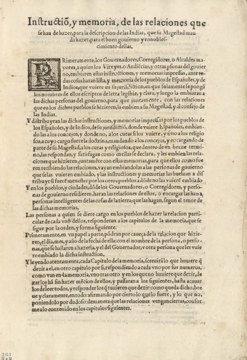
Figure
1 shows the first page (out of three) of the printed
Instrucción y Memoria sent as a guide to the respondents.
The questionnaire included very detailed information about the life in New Spain. One
single query might cover topics such as demography, type of settlements,
intercultural opinions, and ethnolinguistics.
[3] There are also questions about local history, including the
names and settlement of towns, and about agricultural and mineral resources. See
Appendix 1 for a complete translation of the questionnaire.
Responses to the questionnaire were produced between 1579 and 1585 and are now held
in Spain, Scotland, and the United States. In total there are 168 written reports
corresponding to an equal number of main
cabeceras
(“head-towns” or main districts). These also contain descriptions of 248
subordinate jurisdictions, 414 towns and many smaller villages and hamlets [
Cline 1964]. Together they cover more than half the political
subdivisions existing in New Spain circa 1580 [
Cline 1972c].
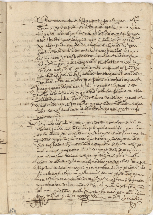
[4]
Figure 2 reproduces one of the manuscript pages of the
Relación de Atlatlauhca (present–day Atlatlauhcán, Morelos).
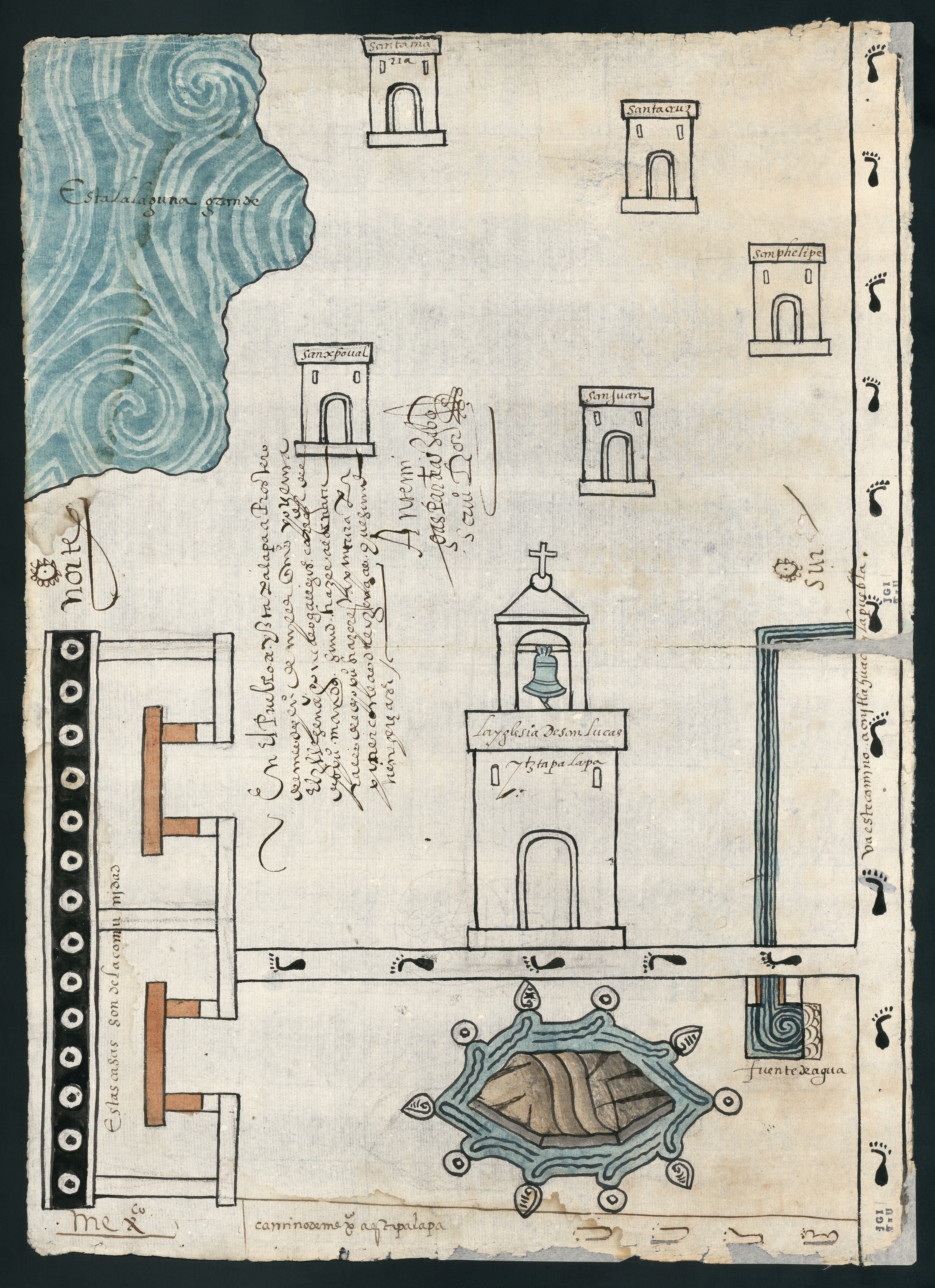
Alongside the texts, the corpus contains 78 maps. Some were painted by indigenous
artists following native representations of places and landscape (
Figure 3 and
Figure 4),
while others were clearly drawn by creoles or peninsular Spaniards (
Figure 5). In the words of
Robertson (1972: 243), they represent “the largest
single group of interrelated early colonial pictorial manuscripts which has come
down to us.”
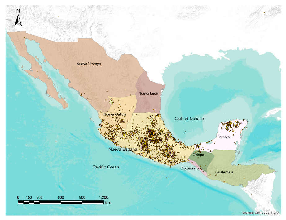
[5] Of these maps, 23 came from
Mexico; 3 from Michoacán; 1 from Nueva Galicia; 21 from Oaxaca; 18 from Tlaxcala; 3
from Yucatán and 2 from Guatemala. There are also accounts of 26 manuscripts and 16
maps lost centuries ago [
Cline 1972c, Table 6]; [
Cline 1972c, Table 10]
[
Robertson 1972], as well as an additional map that disappeared more
recently [
Mundy 1996, 226].
Despite the fact that some authors failed to answer several questions, both the texts
and the maps offer favorable conditions to test new approaches for the analysis of
large historical corpora. The corpus of RGs offers highly structured information —
due to the standardized questionnaire — which gives the reports a degree of
homogeneity rarely seen in other sixteenth–century collections. The geographic
descriptions also cover more than half the territory of New Spain and the level of
detail is remarkable not only in terms of orography, landscape, and natural
resources, but also the way of life of native peoples and colonists, as well as the
interactions between different social groups. Such richness, consistency, and span
facilitate comparative research across small, medium, and large areas on topics of
social, historical, ethnographic, linguistic, economic, and political interest.
A further reason for selecting the RGs is a desire to improve the accessibility and
valorization of the corpus as a main source for historical enquiry. Seminal research
has been conducted by
Cline (1972),
Bravo-García (2018),
Gerhard (1972),
Gruzinski (1991),
Moreno Toscano (1968),
Mundy (1996) and a few other scholars [
Cáceres Lorenzo 2013]
[
Delgado López 2010]. The publications by
Cline
(1972) and
Gerhard (1972), for example,
were ground-breaking works of Mexican historical geography.
Moreno Toscano (1968), on the other hand, used
the complete textual information of the RGs to perform a matrix analysis oriented to
reconstruct the economic geography of New Spain, whilst
Mundy (1996) analyzed all the surviving maps to identify continuities and
changes in the indigenous cartographic tradition during the colonial period. For his
part,
Gruzinski (1991: 77-103) has
approached the corpus by studying how the contrasting — sometimes conflicting —
worldview of conquistadors and native peoples shaped the responses to the
questionnaire, pointing out interesting details about the colonization of the
imaginary.
Single documents of the
Relaciones have also been the
focus of historical research [
Afanador Pujol 2015]
[
Bellesteros García 2005]
[
Barlow 1949]
[
Fernández Christlieb 2006]
[
Morato-Moreno 2017]
[
Mundy 2013]
[
Nuttall 1926] (among others), but in general the textual and
cartographic documents have served as ancillary sources in regional studies, rather
than as a principal mine of data [
Dahlgren de Jordan 1954]
[
Brand 1960]
[
Gibson 1967]. This is due perhaps to the difficulty of cross–linking
information among the many documents or to a lack of tools for uncovering
non–explicit knowledge hidden in the subtext of the answers to the questionnaire.
3. Methodology and current progress
As discussed in the introduction, we are developing advanced tools for unveiling new
information from the RGs corpus by applying a methodology known as Geographical Text
Analysis (GTA). The resulting digital resources and software tools will be released
at the end of the project under an open-access license. The methodology was
originally produced by some members of this project to reveal new, unsuspected
patterns of information by focusing on the geographic components of the historical
narrative [
Cooper and Gregory 2011]
[
Murrieta-Flores et al. 2015]
[
Donaldson et al. 2015]
[
Gregory et al. 2015]
[
Porter et al. 2015]
[
Martins and Murrieta-Flores 2017]
[
Murrieta-Flores et al. 2017]
[
Gregory et al. 2018].
We are now in the process of refining and extending this methodology with
contributions from all members of this project and from researchers engaged in
parallel initiatives (e.g.,
Santos et al. 2017;
Santos et al. 2018;
Won et al.,
2018). In this particular project we followed four phases: obtaining a
computer-readable corpus, the creation of a gazetteer, the semantic annotation and
geoparsing of the corpus, and data mining and historical analysis. In the following
sections, we discuss each stage in detail.
3.1 First phase: Obtaining a computer-readable corpus
The first phase of the methodology is obtaining computer–readable files from the
more comprehensive editions of the RGs. We began with Francisco del Paso y
Troncoso’s Papeles de Nueva España, which contains a
significant portion of the corpus. Transcriptions from the original manuscripts
were already available in electronic format, but it was necessary to identify and
correct significant errors caused by the Optical Character Recognition (OCR)
software. This is a common problem with old documents, to which Alpert–Abrams
offers an approach in her 2016 article on the corpus known as Primeros Libros.
After completing six volumes of
Papeles de Nueva
España (Del Paso y Troncoso 1905), the work continued with the RGs from
Yucatán, published in volume 11 of
Colección de documentos
inéditos de las posesiones de España en ultramar (1898). Additionally,
thanks to a generous permission from the National Autonomous University of Mexico
(UNAM), we were also able to digitize a more recent version of the 54 RGs from
Yucatán transcribed and edited by
De la Garza
(1983) and to acquire in a digital format 114 RGs published in ten
volumes by
Acuña (1982–1988). In the end, we
obtained two versions of the whole corpus in machine–readable format: the first
one includes the notes, references and commentary from the scholars who
transcribed and studied the documents, while the second contains only the
transcription of the original RGs texts. A third version that includes all the NLP
annotations was produced during the third phase of the project.
3.2 Second phase: Creation of a gazetteer
The second phase starts with a compilation of all the place names that exist in
the corpus as well as many others from relevant sources, and then solving any
linguistic and locational uncertainties that prevent their unequivocal
identification.
3.2.2 Linguistic disambiguation.
The resulting list was then subjected to a linguistic disambiguation process,
during which the most difficult challenges were dealing with place names found
in different native languages, as well as resolving name variations and
spelling inconsistencies. Important names of cities, like Tlaxcala, have
remained in original form since the sixteenth century, but many others have
changed significantly over time for a variety of reasons, including: historic
causes;
[6] renaming due to
changes in the boundaries of original settlements;
[7] and addition of words such as the name of a patron saint to
an indigenous toponym.
[8] Another problem relates to spelling variations of the
same toponym,
[9]
the application of Castilian transliterations to the names of ancient
settlements,
[10] or dealing with homonymies.
[11]
State–of–the–art methods to tackle these challenges are discussed in
Nick and Tent (2017) and
Santos et al. (2015,
2017,
2018). Additionally, there is a valuable body of
research on the subject of Mexican toponomy, so we have benefited from
publications by
Anaya Monroy (1960),
Guzmán Betancourt (1987,
1989,
1998),
Lefevre and Paredes Martínez (2017),
León Portilla (2002),
Márquez and Ramos
Navarro Wold (1998),
Mundy (2014),
Muntzel and Villegas Molina (2010), etc. This
adds to the exhaustive research done by the editors of the RGs, especially
Acuña (1982–1988),
De
la Garza (1983) and
Del Paso y Troncoso
(1905).
3.2.3. Geographic disambiguation.
Another challenge at this stage is finding latitude and longitude coordinates
of towns and villages. The solution involves, first, detecting and merging
duplicate entries by comparing the place name list with records found in online
geographical databases, such as the catalogue of indigenous localities,
produced by Instituto Nacional de Estadística Geografía a Informática (INEGI)
and Comisión Nacional para el Conocimiento y Uso de la Biodiversidad (CONABIO);
[12] the geographic dataset created for the cartography of Mexico by INEGI;
the general registrar of archaeological sites compiled by Instituto Nacional de
Antropología e Historia (INAH);
[13] the GeoNames geographical database;
[14] and the Getty Thesaurus of Geographical Names.
[15] Through both linguistic and locational disambiguation, we were able to
obtain 12,748 correct names. Of these, we have so far been able to pin-point
3919 physical locations (
Figure 6), which are the
entries used for the gazetteer.
The structure of the gazetteer complies with Linked Open Data standards to
guarantee its interoperability between different systems and repositories and
facilitate its application into other projects. We have relied on the
experience of massive reference resources like the Getty Thesaurus of
Geographical Names
[16] and
especially the Alexandria Digital Library Gazetteer (ADL), from which we
adopted the relational database schema [
Hill 2000]
[
Hill et al. 1999]. For importing and exporting data, we adopted the
file format JSON, created by the World Historical Gazetteer
[17],
which is now an accepted standard in many textual annotation and analysis
platforms, such as Recogito. The database of our gazetteer will be made
available through the World Historical Gazetteer, the Pelagios Network, and
through Recogito. In addition, the gazetteer will be also available in a
standalone downloadable GIS format from the project’s website and
repositories.
3.3 Third phase: Semantic annotation of the corpus
The third stage comprises four tasks: defining an annotation schema by selecting
the most relevant analytic categories for the intended historical analysis;
annotating manually, and in accordance with the previously defined annotation
schema, two different samples of documents: one for training the NLP deep-learning
model and another one to validate it; tuning the deep-learning model to
automatically perform name entity recognition, disambiguation and classification,
in order to obtain a fully annotated corpus; and assessing the performance of the
model in accordance with the gold-standard validated by experts.
3.3.1 Defining the annotation schema (ontology).
The selection of the ontology categories can be done by consensus among expert
linguists and historians, or with the help of automatic computer methods that
extract a “seed ontology” directly from the corpus
[
Eynard et al. 2012]. The first method is more time-consuming, but it
is simpler and on many occasions yields better results, so this was the
approach we followed.
The RGs ontology contains 21 entity classes and many more sub-categories
relevant to social, political, territorial and economic terms appearing
recurrently through the RGs (Table 2). For example, the general entity class
“architecture” includes sub-categories such as “domestic” and
“religious,” which offers the possibility to distinguish between house
and convent buildings described in texts. Another class “cosmogony”
includes sub-categories such as “ritual,”
“festivity,”
“deity,” etc. Each entity type follows the definitions and linked-data
standards of DBpedia to ensure the interoperability of our dataset.
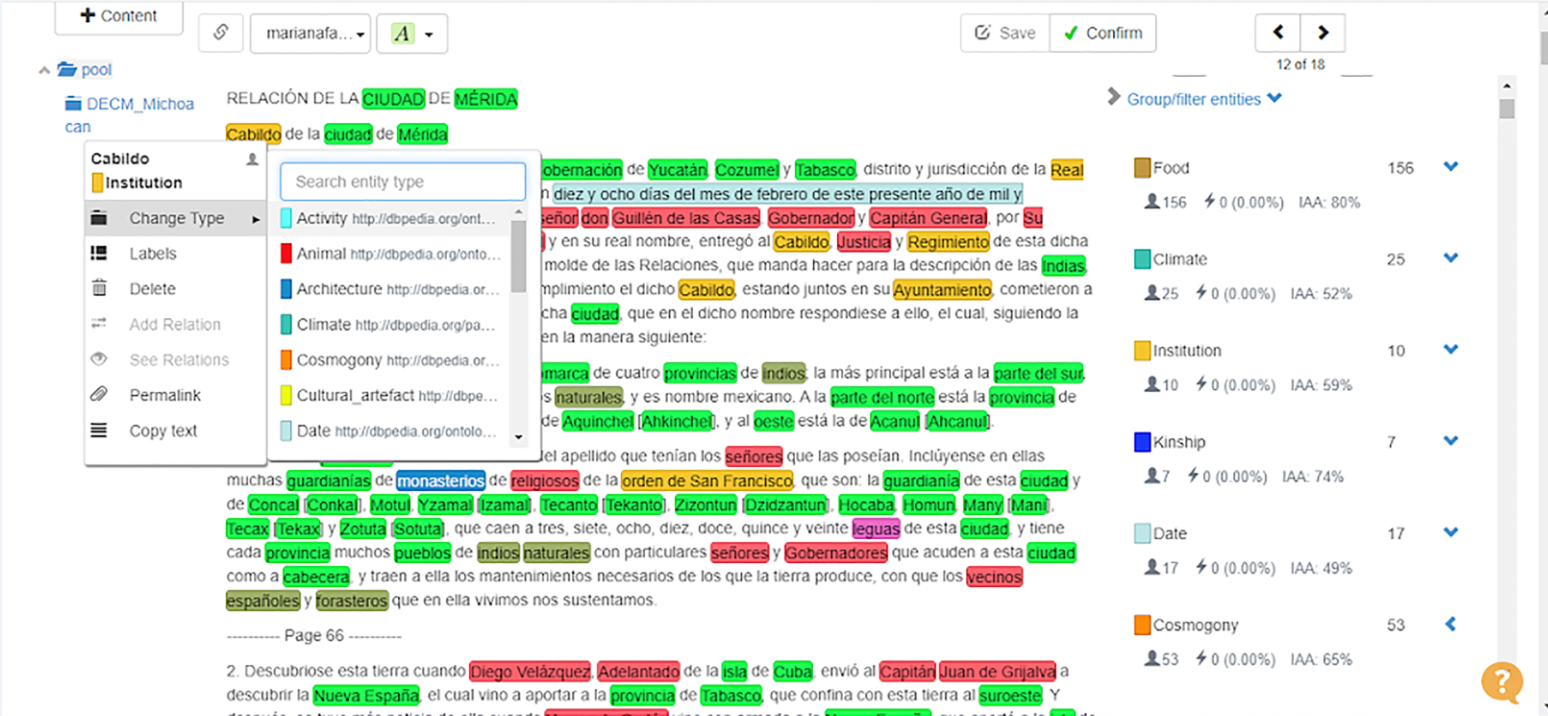
3.3.2 Manual annotation of text samples for training the NLP model.
Using such entity classes we carried out a manual annotation of two samples of
18 out of 168 documents (10% of the corpus) from the RGs using the online
tagging tools developed by Tagtog, a commercial company that generously
provided a free license to our project.
[18] In order to ensure the quality of the
annotated samples, five experts tagged the same documents independently. We
then obtain statistics on the level of consensus among the experts by using the
inter-annotator agreement tool from Tagtog.
Figure
7 illustrates an annotated document.
3.3.3 Development of the NLP deep-learning model.
Once the training and gold-standard sample data are available, the actual
development of the NLP model can begin. Our team in Portugal, led by Bruno
Martins, combined two state-of-the-art approaches of deep-learning: neural
networks and word embedding.
3.3.3.1 Neural networks.
A neural network is a computational model, loosely inspired on the neural
structure of the brain, that is able to “learn by example” how to
perform repetitive complex tasks. In the NLP and CL fields, it is applied,
among other things, to perform word classification, or the assigning of a
label to each word in an input text, indicating whether it belongs to a
certain semantic category (e.g. toponym, person, animal, plant, institution,
cultural concept), or to a “part-of-speech” syntactic category (i.e.
noun, pronoun, adjective, determiner, verb, adverb, preposition,
conjunction, and interjection).
Modern NLP software libraries leverage such statistical models [
Goldberg 2017], making probabilistic decisions on the best
annotations for previously unseen texts. One of the best is SpaCy. To run a
deep-learning model in SpaCy we need to conduct a training phase during
which the software is fed with the training data sample (in our case 10% of
the corpus). This annotated training sample contains many known examples of
the kind of words expected in the unannotated text (the remaining 90% of the
corpus).
Because we know the correct answers — thanks to the gold-standard data
sample — , we can give the model feedback on its predictions in the form of
an error gradient or the loss function that calculates the difference
between the training example and the expected output. If the accuracy of the
annotations is not sufficient, then an iterative refining process can be
carried out until accomplishing satisfactory results.
Then, to link the gazetteer with the corpus texts, it is necessary to assign
correct longitude and latitude coordinates to each toponym recognized by the
neural network. The Mordecai geoparsing library [
Halternamn 2017] is a good tool for that job. It takes as input the place names recognized
by SpaCy, and uses an index over the contents of the gazetteer to find the
potential coordinates of extracted place names. In other words, the names
recognized in the text are matched against similar names in the gazetteer.
Through this process the gazetteer and the corpus are finally linked and
ready for the implementation of query tools.
3.3.3.2 Word-embedding.
Complementing the above procedures, the word–embedding algorithm makes it
easier for the neural network to distinguish all of the different semantic
contexts in which a word might be used. This process follows the idea that
“a word is characterized by the company it
keeps”
[
Firth 1957]. For example, in the phrase “[t]he order of San Francisco was established in these lands in
1524,” the term “San Francisco” refers to an institution, but
in “[t]he mendicant friars helped the poor following the
teachings of San Francisco,” the same term refers to a person. In
another context, it could mean a geographic location, as for instance in the
sentence “San Francisco Tlalcilalcalpan is inhabited at
the present by 18,721 people.”
We specifically pre-trained a word–embedding algorithm in an unsupervised
way to statistically predict the meaning of words in the context of real
natural language utterances. Thus, we needed training data sufficiently big
and varied to tackle the specific challenges of the RGs. One is that the
spelling in the corpus varies considerably among the many authors. This is
sometimes, in part, because words are spelled in accordance with their Latin
origin, rather than their actual pronunciation. Another is that the corpus
borrows heavily on vocabulary from indigenous languages, especially place
names, and terms to identify flora, fauna, cultural concepts, etc.
Given the fact that the structure of modern Spanish still resembles to a
high degree the language recorded in the RGs, we decided to combine modern
and historical data sources to train our model. Contemporary data came from
several Spanish corpora such as ANCora [
Taulé et al. 2008], IMPACT-es
[
Sánchez–Martínez et al. 2013], or the
Corpus
del Español,
[19] while numerous examples of sixteenth–century Spanish texts from
different archives and ten dictionaries of indigenous languages [
García Cubas 1888-1891]
[
Peñafiel 1987]
[
Robelo 1897]
[
Robelo 1900]
[
Robelo 1902a]
[
Robelo 1902b]
[
Robelo 1904]
[
Robelo 1905]
[
Starr 1920] provided resources to deal with the language
complexities particular to New Spain.
By thus leveraging modern and historical data in a combined training
dataset, we can simultaneously benefit from having large amounts of
contextual information from which the model can learn more easily, together
with some data representing the specificities of historical Spanish.
Furthermore, to avoid problems with out-of-vocabulary words, such as those
brought forward by the inconsistent spelling or cultural expressions, we
used a word–embedding method that also creates representations for
sub-words, and which is able to reconstruct entire word representations from
such sub-words [
Bojanowski et al. 2017].
4. Future Work: Data mining and historical analysis
At this stage, several data mining and analysis procedures can be carried out. The
first is an adaptation of collocation analysis — a technique from Corpus Linguistics
(CL) — which allows for extracting the most statistically significant phrases that
are found next to a term or keyword of interest (the “collocates,” in CL
jargon). Our variant of the technique is
geographic collocation
analysis, originally developed by the research group at Lancaster [
Gregory et al. 2015]
[
Murrieta-Flores et al. 2015]
[
Murrieta-Flores et al. 2017]
[
Murrieta-Flores and Gregory 2017]. This facilitates the recognition and
retrieval, across the corpus, of all place names that collocate or are close to a
keyword of interest according to a predefined proximity threshold, usually defined in
terms of the maximum number of words between the search–term and the collocate. In
this manner, if a researcher is interested in investigating economic aspects related
to agriculture, they could retrieve, for instance, all phrases in the context of
words like
maíz,
siembra,
subsistencia,
mantenimientos,
comida
(i.e. “maize”, “sowing”, “subsistence”, “sustenance”,
“food”), which would appear linked to a map showing the geographic locations
where such terms appear.
Furthermore, by putting words in context through collocation, a historian could
extract in a few seconds — as opposed to the weeks that it would take to access the
information without GTA tools — interesting details about the first colonists in New
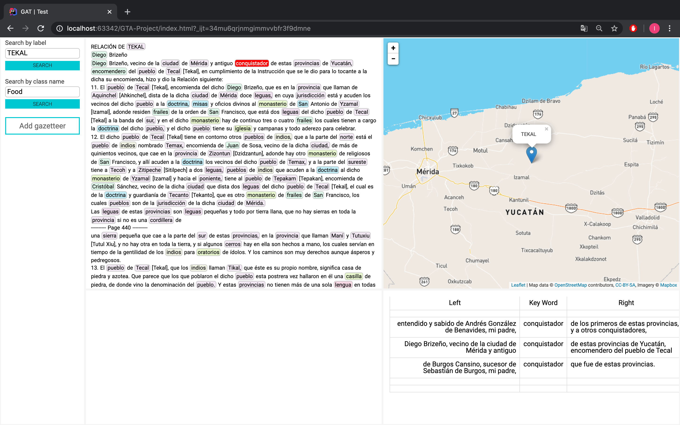
Spain. Such a query, for instance, might involve running a collocate search of the
word “conquistador” (
Figure 8). Another type of search
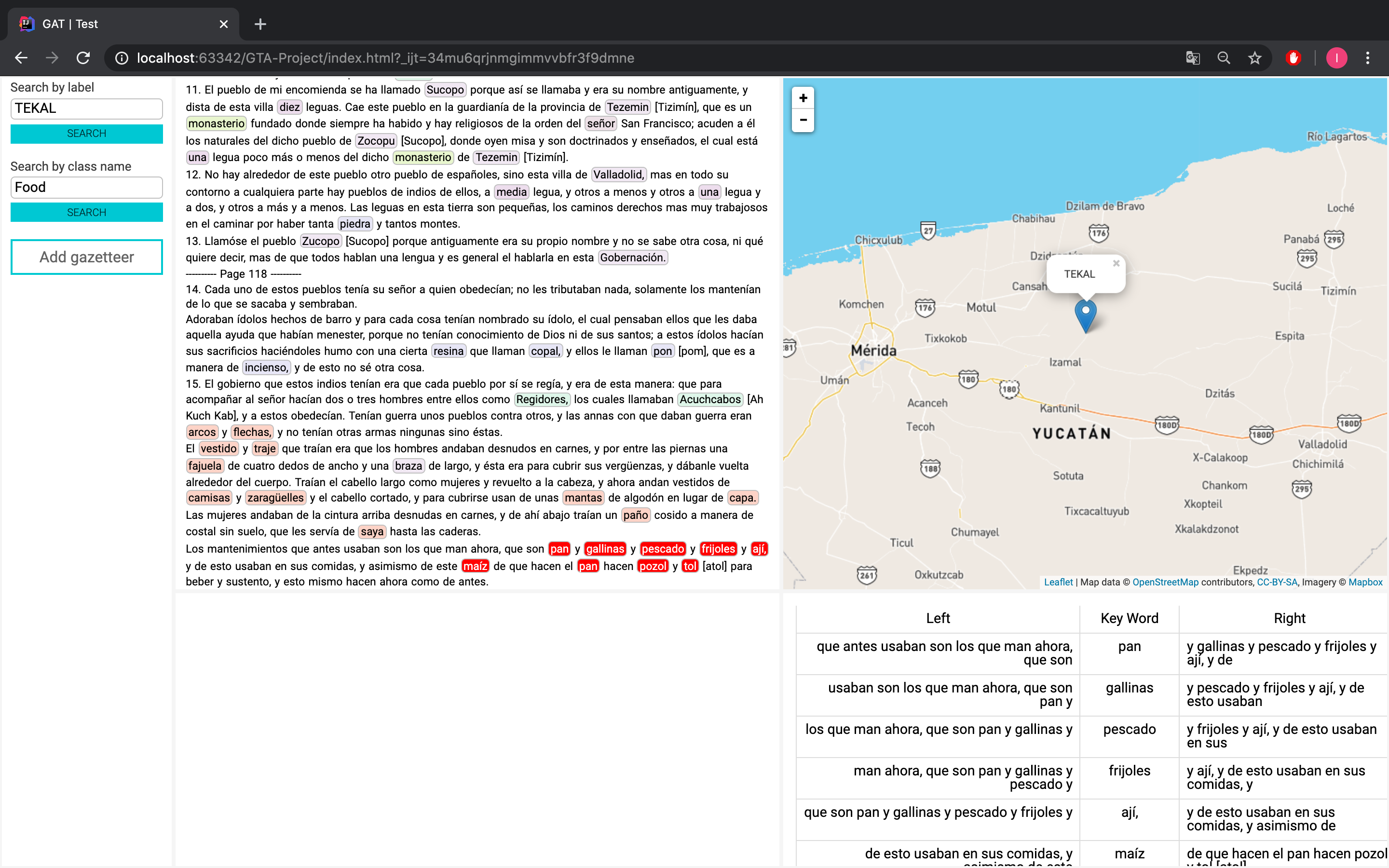
can be conducted using general categories, such as employing the term “food” to
retrieve words like “beans,”
“fish,” or “bread” (
Figure 9).
In the following subsections, we highlight several topics of historic analysis that
we plan to examine through this research.
4.1 Historical phenomena changing the face of New Spain at the end of the
sixteenth century
One area of application for the techniques detailed in this study is understanding
the coexistence of competing systems of land ownership and labor in New Spain
during the colonial period. In New Spain during the short time of compilation of
the RGs, there was a strong debate about the system of encomiendas and the desire to replace it with the so-called repartimientos. The encomienda was the right to exploit the labor of indigenous
populations, granted by the Spanish Crown to conquistadors, who at the beginning
of the colonization held this privilege in perpetuity and could, therefore, pass
it to their descendants with little intervention from the royal government in
Madrid. In contrast, the repartimiento only
allocated the labor force of native workers for a fixed period of time in exchange
for a meager remuneration. The latter gave the royal government more control over
its subjects and resources. Neither the holders of encomiendas nor repartimientos were
allowed to appropriate lands, as private property was reserved for haciendas. These three systems coexisted in the 1570s
despite the enactment of the so-called New Laws in 1542, which attempted to
protect the rights of the indigenous populations and prevent the dispossession of
their lands by abolishing the encomiendas.
Throughout the texts of the RGs, therefore, it is common to find claims by
conquistadors’ descendants of their encomienda
rights, and others defending the benefits of repartimientos. A comprehensive study of the claims and contentions
found in the RG corpus would improve our understanding of the period.
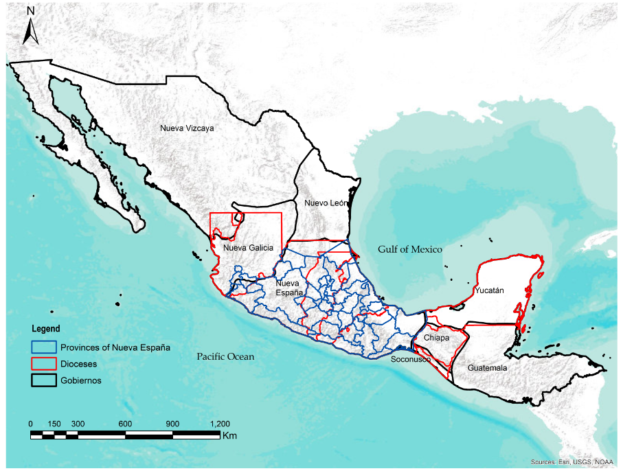
4.2 The local government organization of New Spain toward the third quarter of
the sixteenth century
A second application of these methodologies has to do with disambiguating local
structures of governance in New Spain. The early colonial period was a time when
the functions and spheres of influence of the four branches of colonial government
were not well defined, and consequently the spatial boundaries of the judicial,
administrative, military and ecclesiastical jurisdictions overlapped (
Figure 10). This was especially true at the municipal
level. Consequently, the corpus contains terms associated with several kinds of
jurisdictions whose meanings were not consistent throughout the vast territory of
New Spain (e.g.
partidos de clérigos,
distrito de mision,
custodia,
guardianía,
vicaría, presidencia, etc.). The subject has been a matter of ongoing
debate among historians [
Gerhard 1972b, 66], but we believe
that applying collocation analysis for extracting the contextual use of such words
would shed light on how those institutions functioned in parallel to
alcaldías mayores and
corregimientos and this would be an important contribution to the
knowledge of this period.
4.3 Settlement pattern analysis to elucidate the territorial organization of
New Spain
A third area for future study has to do with demarcating the boundaries of
territories in New Spain. By reading the RGs, we could attempt to identify the
names and boundaries (
linderos) of towns
belonging to
corregimientos (territorial
demarcations for administrative and judicial purposes) mentioned in the corpus.
Circa 1570, there were 200 of such units whose frontiers have been outlined by
Gerhard (1972a). However, the smaller
demarcations (towns, villages) suffered adjustments in boundaries and
jurisdictions. As Gerhard points out, at the time of the RGs, “[e]arly civil and ecclesiastical divisions lost importance and were
eliminated; others came into being as a result of conquest, proselytization,
mining activity, and other causes”
[
Gerhard 1972b, 66–9]. The application of a mathematical model
that analyzes the maximum available territory around each settlement within a
region, like the one proposed by
Ducke and Kroefges
(2008), could provide preliminary hypotheses on such demarcations. These
would then be tested against the actual historical information extracted from the
corpus through geographic collocation analysis. One of the many ways that such a
study could begin is by extracting references on the routes that local
administrators take for their visits to towns within their jurisdiction, the
distances they traversed, the geographic features and topography of the landscape,
etc. (
Figure 10) This, and much other information,
is available throughout the corpus, but more specifically in the answers to
questions 7, 8, 11, and 12 (see
Appendix 1).
4.4 Analysis of historical diseases
A fourth research question has to do with our understanding of the outbreak of
disease (1576-1581) that took the lives of half the population of New Spain during
the early colonial period [
Acuña–Soto et al. 2004]. This was the second
time that
cocoliztli (as the epidemic was called)
had decimated the native population, causing the disappearance of whole
communities, shortages in labor-force for the
encomiendas and
repartimientos, the
displacement of people over different regions, or, on the contrary, the
congregation of survivors (sometimes of different ethnic communities) in new
Indian towns, all of which altered dramatically the traditional settlement pattern
[
Gerhard 1972a, 24]. How did this phenomenon vary over
different regions? How many people died in each locality? How did this epidemic
compare with others in the past? How did the new settlement change in comparison
with Prehispanic times? These are all questions that GTA could help to answer by
collocating words and phrases related to health (such as diseases, symptoms, and
remedies) and analyzing them with spatial mathematical models of disease
contagion.
4.5 The spatial distribution of natural resources (flora, fauna, minerals,
etc.) and exploitation practices at the time of the RGs
A fifth application of our methodology has to do with the study of natural
resources. GTA will allow the extraction and analysis of regional historical
information on natural resources such as plants. There are already interesting
archaeological, historical and ethnographic research related to plants and their
use in Mesoamerica, medicinal and otherwise [
Albores Zarate 2015]
[
Chávez Mejía et al. 2020]
[
Hersch 1999]. Some further research has been also dedicated to
assessing the importance of the trees and edible plants introduced by Europeans.
With the annotation of the RGs in this project and the development of GTA, it is
now possible not only to extract information regarding native and European plants
introduced in the different regions of New Spain, but also to contribute to
further debates. It is known, for instance, that Mesoamerican cultures had an
extended knowledge of plants for medicinal use and most of the research about this
has been carried out using colonial primary sources. We could now create a map of
all the plants mentioned in the RGs and compare this dataset with archaeological
data and other primary sources that were dedicated to the recording of medicinal
plants, such as the Códice Badiano or the Historia Natural de Nueva España. This
would allow researchers, for instance, to assess the continuation in the use of
specific plants for remedies and consumption in specific regions of New Spain.
Other interesting avenues of possible research with GTA analysis are the
availability of food and animals both native and introduced, the use of natural
resources, the existence of cultural artefacts, the presence of priests and
religious orders in particular regions, as well as types of architecture.
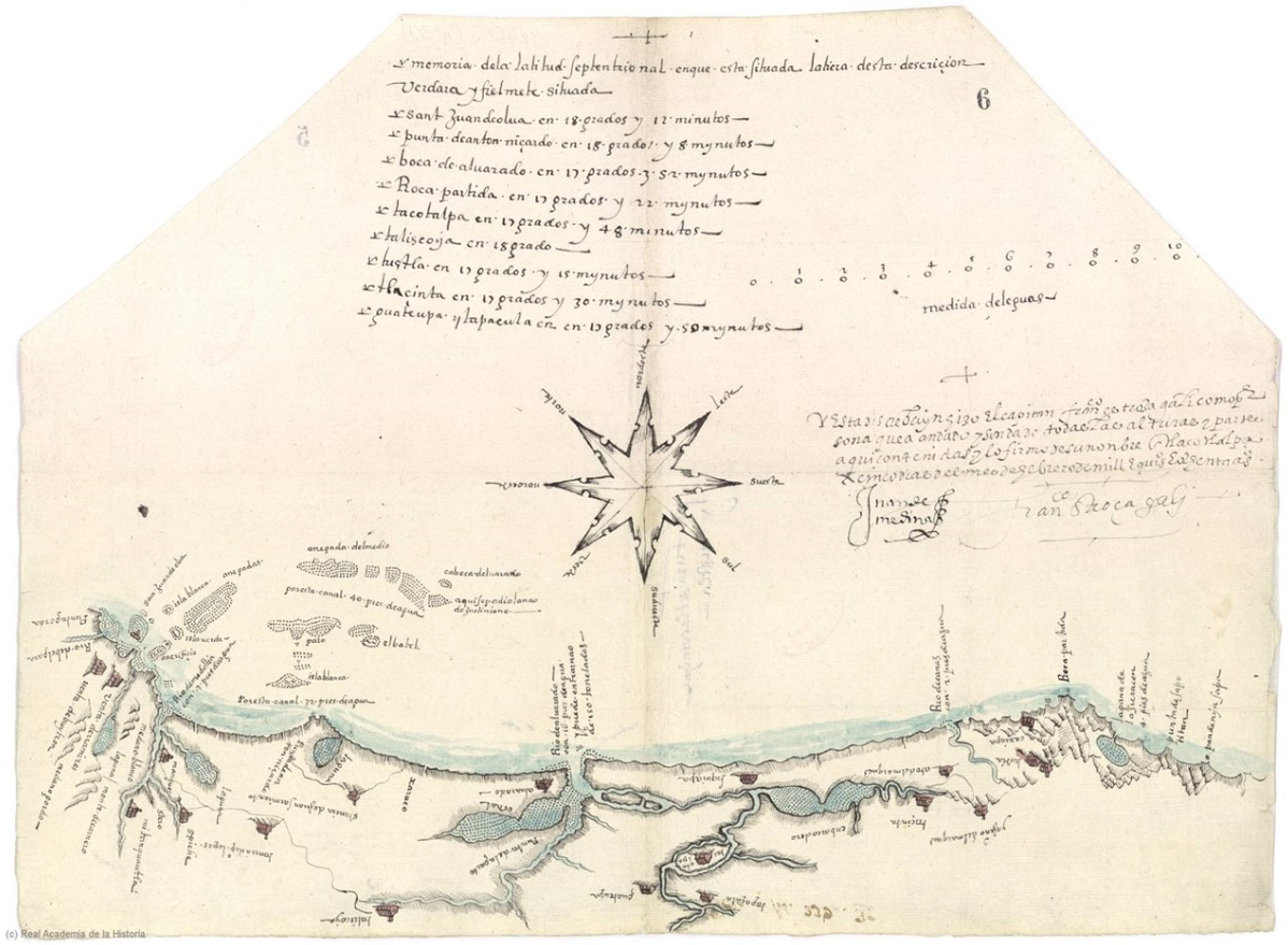
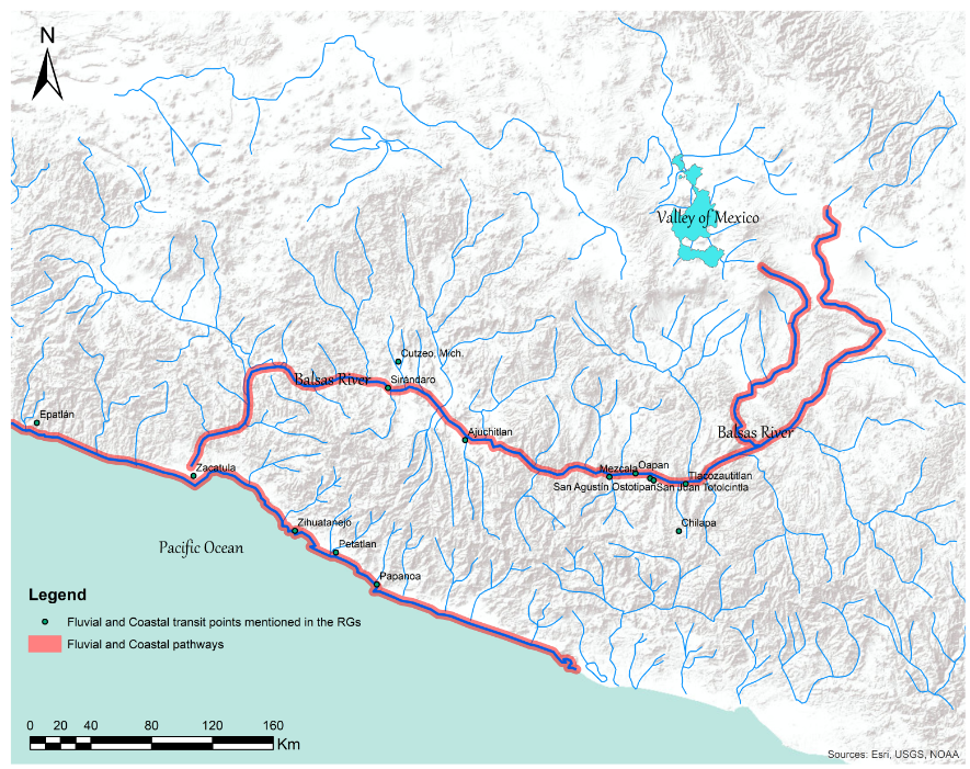
4.6 Exchange networks, trading practices and communication routes
An additional topic is the study of exchange networks and trading practices, as
well as communication routes, both terrestrial and aquatic, among the populations
described in the RGs. One such study has already been conducted by
Favila-Vázquez (2019), who successfully
reconstructed aquatic communication networks in the Rio Balsas region by
extracting information from the responses available to queries 38 to 47 of the RGs
(
Figure 11). These contain crucial data regarding
navigation by sea, including location of ports and coastal landscape. Together
with data from question 19 (focused on fluvial networks), the extraction of data
from the RGs corpus allowed Favila-Vázquez to reconstruct a riverine and coastal
system of communication that explains the spatial connectivity of the Valley of
Mexico to the Pacific coast.
5. Conclusion
Geographical Text Analysis can make an important contribution to the study of massive
corpora, like the RGs, by expediting the extraction and analysis of specific
information that would be too slow or cumbersome to find in big datasets through
traditional reading methods. It also can provide tools to uncover patterns behind the
narrative of historical sources and link them to their geographic locations. Thus,
GTA creates a way for historians to apply what in computational literary studies is
called “distant reading.”
[20]
At the same time, the use of geographic collocations and the concept of “keywords
in context” permit a more detailed, granular comprehension of the corpus by
identifying those parts that deserve a “close reading.” This flexibility has
been demonstrated in previous research projects employing GTA [
Donaldson et al. 2017]
[
Murrieta-Flores et al. 2017]
[
Taylor et al. 2017]. Having a multiplicity of “ place names in context”
associated with keywords of interest opens an unprecedented range of possibilities in
terms of identifying information patterns and hypothesis–testing across large
corpora, which in turn allows answering historical questions in a way that would be
impossible otherwise.
In such a context, the proposal of GTA must not be seen as an attempt to replace the
careful micro study of historical sources practiced by modern historians. More
exactly, GTA is a methodology for parsing and crosslinking information at a macro
scale throughout a whole corpus in a relatively short period of time, so historians
can use their efforts and time more efficiently to focus on the more important
documents or fragments of texts.
One of the main contributions of our project specifically has been adapting named
entity recognition, disambiguation, and classification techniques to text collections
that either belong to specific historical periods or might pose a further challenge
due to their multi–language nature. We have succeeded in developing a new
deep-learning model to process the language of the RGs despite the orthographic
variance across the corpus and the high frequency of indigenous vocabulary.
Nevertheless, there is still much work to be done, especially for the indigenous
languages of the Americas [
Mager et al. 2018].
Finally, we have already produced a significant number of digital datasets of value,
such as the gazetteer, which includes not only sixteenth–century localities but place
names from other Mexican historic periods. Hopefully, these will prove valuable
resources for humanists engaged in studying the Latin American historical and
archaeological past. The methods and tools being developed by the project have the
advantage of being generic, and therefore, applicable to other corpora.
We are committed to releasing the digital products and software tools through several
repositories, including GitHub and our own online platform. Our hope is that scholars
from diverse fields will be able to identify the desired information, extract it,
cross–link it to other document resources, and most importantly, answer significant
research questions: Where do certain phenomena happen more often? Who was responsible
for certain events? What was happening in specific places at certain times? Such kind
of enquiry will take historical analysis a step further, contributing significantly
to advancing research on the colonial period in Latin America, and humanities
research more generally.
Appendix 1. The Questionnaire of the Relaciones Geográficas[21]
Memorandum Of The Things That Are To Be Answered, And Of That Which Shall Be
Taken Into Account.
- Firstly: For towns of Spaniards, state the name of the district or province in
which it lies. What does this name mean in the native language, and why is it so
called?
- Who was the discoverer and conqueror of this province? By whose order was it
discovered? In what year was it discovered and conquered, as far as is readily
known?
- What is the general climate and character of the province or district? Is it
very cold or hot, humid or dry? Does it have much or little rain, and when,
approximately, does it fall? How violently and from where does the wind blow, and
at what times of the year?
- Is the terrain flat or rugged, clear or wooded, with many or few rivers or
springs, abundant in or lacking water? Is it fertile or without pasture, abundant
or lacking in fruits and sustenance?
- Are there many or few Indians? Were there more or fewer at other times, and
what are the known causes of this? Are they presently settled in planned and
permanent towns? Describe the degree and quality of their intelligence,
inclinations, and way of life. Are there different languages in the province or a
general language that all speak?
- What is the latitude, or the altitude of the Pole Star, at each Spanish town,
if it has been taken and is known, or if anyone knows how to observe it? Or on
which days of the year does the sun not cast a shadow at midday?
- What are the league distances and the direction of each Spanish city or town in
the district to the city of its Audiencia, or to the
town where the governor to whom it is subject resides?
- Likewise, what are the league distances and the direction of each Spanish city
or town to adjacent ones? Are these leagues long or short, through flat or hilly
land, over straight or winding roads, easy or difficult to travel?
- What are the present and former names and surnames of each city or town? Why
are they so called, if known? Who gave each its name, who was its founder, by
whose order was it settled? What year was it founded? How many residents did the
settlement first have, and how many does it have now?
- Describe the sites upon which each town is established. Is each upon a height,
or low-lying, or on a plain? Make a map of the layout of the town, its streets,
plazas and other features, noting the monasteries, as well as can be sketched
easily on paper. On it show which part of the town faces south or north.
- For native towns, state only how far they are from the town in whose
corregimiento or jurisdiction they are, and how far they lie from their cabecera
de doctrina.
- In addition, state how far the native towns lie from surrounding native or
Spanish towns. Declare for all their direction from these other towns. Are the
leagues long or short, the roads through level or hilly land, straight or
winding?
- What does the name of this [native] town mean in the indigenous language? Why
is it called this, if known? What is the name of the language spoken by the
natives of this town?
- Who were their rulers in heathen times? What rights did their former lords have
over them? What did they pay in tribute? What forms of worship, rites, and good or
evil customs did they practice?
- How were they governed? With whom did they wage war? How did they battle? What
was their battle dress and clothing like, both formerly and now? What was their
former and is their present means of subsistence? Were they more or less healthy
than now and what are reasons for this that you may know?
- For all towns, both Spanish and native, describe the sites where they are
established. Are they in the mountains, in valleys, or on open flat land? Give the
names of the mountains, valleys, and districts, and for each, tell what the name
means in the indigenous language.
- Is the land or site healthy or unhealthy? If unhealthy, why (if it is known)?
What illnesses commonly occur, and what cures are commonly used for them?
- How far or near, and in what direction does each town lie from a nearby
prominent mountain or range? Supply its name.
- What major river or rivers flow nearby? How distant and in what direction do
they lie? How great is their flow? Is there anything notable known about their
sources, water, orchards and other growth along their banks? Are there or could
there be irrigated lands of value?
- What are the significant lakes, lagoons, or springs within the town boundaries?
Note anything remarkable about them.
- What are the volcanoes, caves, and all other notable and remarkable aspects of
nature in the district worthy of being known?
- Which wild trees and their fruits are commonly found in the district? What are
the uses of them and their woods, and to what good are they or could they be
put?
- Which cultivated trees and fruit orchards are in the region? Which were brought
from Spain and elsewhere? Do these grow well?
- What are the grains and seed plants, and other garden plants and vegetables
that are or have been used as sustenance for the natives?
- Which were brought from Spain? Does the land yield wheat, barley, wine, or
olive oil, and in what quantities? Is there silk or cochineal in the region, and
in what quantities?
- What are the herbs or aromatic plants that the natives use for healing? What
are their medicinal or poisonous properties?
- What animals and birds, both wild and domestic, are in the region? Which ones
were brought from Spain, and how well have they bred and multiplied?
- In the region or within the town lands, are there any gold or silver mines or
sources of other metals, or black or colored pigments?
- Are there any quarries of precious stone, jasper, marble, or other notable
ones? What value might they have?
- Are there sources of salt in the town or nearby? If [residents] lack salt and
other items necessary for their sustenance or clothing, where do they procure all
these things?
- How are the houses built and what is their form? What building materials are
found in the town, or brought from elsewhere?
- What are the towns' fortifications? Are there barracks, or any fortified or
impregnable places within the boundaries of the district?
- Through what dealings, trade, and profits do both Spaniards and Indians live
and sustain themselves? What are the items involved and with what do they pay
their tribute?
- In which diocese of the archbishopric, bishopric, or abbey does each town lie?
In which district does each lie? How many leagues and in which direction does each
town lie from the town of the cathedral and the cabecera of the district? Are the
leagues long or short, along straight or winding roads, and through flat or hilly
land?
- In each town, what are the cathedral and parish church or churches? What is the
number of endowed church offices and allotments for clergymen's salaries in each?
Do any have a chapel or significant endowment, and, if so, whose it is and who
established it?
- What are the monasteries or convents of each Order? By whom and when were they
founded? How many notable things do they contain? And what is the number of
religious?
- What are the hospitals, schools, and charitable institutions in the towns? By
whom and when were they founded?
- If the towns are on the seacoast, in addition to the above, report in your
account the nature of the sea in the vicinity, whether it is calm or stormy, the
nature of the storms and other dangers. What times, approximately, are they
frequent?
- Is there beach or cliffs along the coast? What are the prominent reefs and
other dangers to navigation along it?
- How great are the tides and tidal ranges? On which days and at which hours do
they occur? In which season are they greater or lesser?
- What are the notable capes, points, bights, and bays in the district? Note
their names and sizes, as well as can be determined.
- What are the ports and landings along the coast? Make a map showing their shape
and layout as can be drawn on a sheet of paper, in which form and proportion can
be seen.
- What is their size and capacity? Note their approximate width and length in
leagues and paces, as well as can be determined. Also note how may ships they will
accommodate.
- What is the depth in fathoms of each? Is the bottom clear? Are there any
shallows and shoals? Indicate their locations, and whether the port is free of
shipworm and other impediments.
- What directions do their entrances and exits face? With which winds must one
enter and depart?
- What are their advantages or lack of them in the way of firewood, water, and
provisions? What are the favorable or unfavorable considerations for entering and
remaining?
- What are the names of the islands along the coast? Why are they so named? Make
a map, if possible, of their form and shape, showing their length, width, and lay
of the land. Note the soil, pastures, trees, and resources they may have, their
birds and animals, and the notable rivers and springs.
- Where are the abandoned Spanish towns located in the region? When were they
settled and abandoned? What is known about the reasons for abandonment?
- Describe any other of the notable aspects of nature, and any notable qualities
of the soil, air, and sky in any part of the region.
- Having completed the account, the persons who have collaborated on it will sign
it. It must be returned without delay, along with these directions, to the person
from whom it was received.
Annotation schema table
| Entity |
Ontological definition |
Labels |
| Person |
http://dbpedia.org/page/Person |
female/male, title, profession |
| Date |
http://dbpedia.org/ontology/date |
|
| Institution |
http://dbpedia.org/page/Institution |
civil, ecclesiastical |
| Location |
http://dbpedia.org/ontology/location |
settlement type, generic location, geographic feature type, toponym,
address, imaginary, ecclesiastical jurisdiction, civil jurisdiction |
| Activity |
http://dbpedia.org/ontology/activity |
agriculture, warfare, economy, mining, domestic, female/male |
| Animal |
http://dbpedia.org/ontology/animal |
insect, mammal, reptile, bird, amphibian, aquatic, domesticated |
| Plant |
http://dbpedia.org/page/Plan |
|
| Food |
http://dbpedia.org/page/Food |
|
| Natural Resource |
http://dbpedia.org/page/Natural_resource |
|
| Cultural artefact |
http://dbpedia.org/page/Cultural_artifact |
house goods, commodities, clothing, weapon, tool |
| Architecture |
http://dbpedia.org/page/Architecture |
religious, civil, domestic |
| Cosmogony |
http://dbpedia.org/page/Cosmogony |
ritual, festivity, activity, deities, saints, object |
| Health |
http://dbpedia.org/page/Health |
disease, remedy |
| Route of Transportation |
http://dbpedia.org/ontology/RouteOfTransportation |
terrestrial, aquatic, route direction, distance |
| Kinship |
http://dbpedia.org/page/Kinship |
|
| Climate |
http://dbpedia.org/page/Climate |
|
| Ethnic Group |
http://dbpedia.org/page/Ethnic_group |
|
| Social Class |
http://dbpedia.org/page/Social_class |
|
| Language |
http://dbpedia.org/page/Language |
|
| Event |
http://dbpedia.org/page/Event |
historical, disasters |
| Measurement |
http://dbpedia.org/page/Measureme |
value, tribute, weight, population |
Table 1.
Annotation schema: entities, DBpedia definitions and labels per entity.
Acknowledgements
We would like to thank the generous grant awarded by the 2017 T–AP initiative of the
Trans–Atlantic Platform in Social Sciences and Humanities Research, as well as the
support received in each country by the Economic and Social Research Council (ESRC,
UK) (ES/R003890/1), the Foundation for Science and Technology (FCT, Portugal), and
the Consejo Nacional de Ciencia y Tecnología (project 275015). Likewise, we would
like to thank the Red Conacyt de Tecnologías Digitales para la Difusión del
Patrimonio Cultural (project 294971), also supported by Conacyt.
Works Cited
Acuña–Soto et al. 2004 Acuña–Soto, Rodolfo, David
W. Stahle, Matthew D. Therrell, Richard D. Griffin, and Malcolm K. Cleaveland. 2004.
“When half of the population died: The epidemic of hemorrhagic
fevers of 1576 in Mexico”.
FEMS Microbiology
Letters 240(1): 1–5. doi:
10.1016/j.femsle.2004.09.011.
Afanador Pujol 2015 Afanador Pujol, A. (2015).
The relación de Michoacán (1539-1541) and the politics of
representation in colonial Mexico. University of Texas Press.
https://doi.org/10.7560/771383.
Albores Zarate 2015 Albores Zarate, B. (Ed.).
2015. Flor-flora: Su uso ritual en Mesoamérica. Toluca
de Lerdo, Estado de México : Fondo Editorial Estado de México; El Colegio
Mexiquense.
Anaya Monroy1960 Anaya Monroy, Fernando. 1960.
“Presencia espiritual de la cultura náhuatl en la
toponimia”. Estudios de Cultura Náhuatl 2:
9–25.
Barlow 1949 Barlow, Robert H. 1949. “Relación de Zempoala y su partido, 1580”. Tlalocan. Revista de Fuentes para el Conocimiento de las Culturas
Indígenas de México 3(1): 29-41.
Bellesteros García 2005 Ballesteros García,
Víctor Manuel. 2005.La Pintura de la Relación de Zempoala de
1580. México: Universidad Autónoma del Estado de Hidalgo.
Bojanowski et al. 2017 Bojanowski, Piotr, Edouard
Grave, Armand Joulin, and Tomas Mikolov. “Enriching Word Vectors
with Subword Information.”
Transactions of the Association for Computational
Linguistics 5 (2017): 135-46.
Borin et al. 2007 Borin, Lars, Dimitrios Kokkinakis,
and Leif–Jöran Olsson. 2007. “Naming the past: Named entity and
animacy recognition in 19th century Swedish literature”. In
Proceedings of the Workshop on Language Technology for Cultural
Heritage Data (LaTeCH 2007), pp. 1–8. Prague, Czech Republic: Association
for Computational Linguistics.
http://www.aclweb.org/anthology/W/W07/W07–0901.pdf.
Brand 1960 Brand, Donald. 1960. Coalcoman and Motines del Oro, an ex-Distrito of Michoacan, México.
Austin: University of Texas, Institute of Latin American Studies.
Bravo-García 2019 Bravo-García, Eva. 2019.
Las voces del contacto. Edición y estudio de Las Relaciones
Geográficas de México (Siglo XVI). Warsaw: University of Warsaw.
Brooke et al. 2015 Brooke, Julian, Adam Hammond, and
Graeme Hirst. 2015. “GutenTag: An NLP–driven tool for digital
humanities research in the project Gutenberg Corpus”. In
Proceedings of the North American Association for Computational
Linguistics, pp. 1–6. Denver, Colorado.
http://www.cs.toronto.edu/pub/gh/Brooke–etal–2015–CLfL.pdf.
Byrne 2007 Byrne, Kate. 2007. “Nested named entity recognition in historical archive text”. In
International Conference on Semantic Computing (ICSC 2007).
Irvine, CA, USA: IEEE.
Doi:10.1109/ICSC.2007.107.
Cline 1964 Cline, Howard F. 1964. The “Relaciones Geográficas of the Spanish Indies, 1577–1586”.
The Hispanic American Historical Review 44(3):
341–374.
doi:10.2307/2511856.
Cline 1972a Cline, Howard F. 1972a. “Introductory notes on territorial divisions of Middle
America”. In Handbook of Middle American Indians,
Volume 12: Guide to Ethnohistorical Sources, Part One, edited by Howard F.
Cline, pp. 17–62. Austin: University of Texas Press.
Cline 1972b Cline, Howard F. 1972b. “Ethnohistorical regions of Middle America”. In Handbook of Middle American Indians, Volume 12: Guide to
Ethnohistorical Sources, Part One, edited by Howard F. Cline, pp. 166–182.
Austin: University of Texas Press.
Cline 1972c Cline, Howard F. 1972c. “The Relaciones Geográficas of the Spanish Indies, 1577–1648”.
In Handbook of Middle American Indians, Volume 12: Guide to
Ethnohistorical Sources, Part One, edited by Howard F. Cline, pp. 183–242.
Austin: University of Texas Press.
Cline 1972d Cline, Howard F. 1972d. “A census of the Relaciones Geográficas
of New Spain, 1579–1612”. In Handbook of Middle
American Indians, Volume 12: Guide to Ethnohistorical Sources, Part One,
edited by Howard F. Cline, pp. 364–369. Austin: University of Texas Press.
Cooper and Gregory 2011 Cooper, David, and Ian N
Gregory. 2011. “Mapping the English Lake District: A literary
GIS”.
Transactions of the Institute of British
Geographers 36(1): 89–108.
doi:10.1111/j.1475–5661.2010.00405.x.
Crane and Jones 2006 Crane, Gregory and Alison Jones.
2006. “The challenge of Virginia Banks: An evaluation of named
entity analysis in a 19th–century newspaper collection”. In
Proceedings of the 6th ACM/IEEE–CS Joint Conference on Digital
Libraries (JCDL ‘06), Chapel Hill, NC, USA: ACM Press.
doi:10.1145/1141753.1141759.
Cáceres Lorenzo 2013 Cáceres Lorenzo, María
Teresa. 2013. “Tipos de Relaciones Geográficas en el siglo
XVI”. Crítica Hispánica 35(1): 45-66.
Dahlgren de Jordan 1954 Dahlgren de Jordan, Barbro.
1954. La Mixteca: su cultura e historia
prehispánicas. México: Universidad Nacional Autónoma de México.
De la Garza 1983 De la Garza, Mercedes (Ed.). 1983.
Relaciones histórico–geográficas de la gobernación de
Yucatán: (Mérida, Valladolid y Tabasco). First edition, 2 vols. México:
Universidad Nacional Autónoma de México.
Del Paso y Troncoso 1905 Del Paso y Troncoso,
Francisco (Ed.). 1905. Papeles de Nueva España. Segunda
Serie: Geografía y Estadística, vols. 1, 3–7. Madrid: Sucesores de
Rivadeneyra.
Delgado López 2010 Delgado López, Enrique. 2010.
“Las Relaciones Geográficas como proyecto científico en los
albores de la modernidad”. Estudios
Mesoamericanos 2(9): 97–106.
Donaldson et al. 2015 Donaldson, Christopher, Ian
N. Gregory, and Patricia Murrieta–Flores. 2015. “Mapping
‘Wordsworthshire’: A GIS study of literary tourism in Victorian
Lakeland”.
Journal of Victorian Culture 20(3):
287–307.
doi:10.1080/13555502.2015.1058089.
Donaldson et al. 2017 Donaldson, Christopher, Ian
N. Gregory, and Joanna E. Taylor. 2017. “Locating the beautiful,
picturesque, sublime and majestic: Spatially analysing the application of
aesthetic terminology in descriptions of the English Lake District”.
Journal of Historical Geography 56 (April): 43–60.
doi:10.1016/j.jhg.2017.01.006.
Ducke and Kroefges 2008 Ducke, Benjamin and Peter C.
Kroefges. 2008. “Layers of Perception”.
Proceedings of the 35th International Conference on Computer
Applications and Quantitative Methods in Archaeology (CAA2007), Berlin,
Germany, April 2–6, edited by Axel Posluschny, Karsten Lambers, and Irmela Herzog,
pp. 246-251. (Kolloquien zur Vor- und Frühgeschichte, Vol. 10). Bonn: Dr. Rudolf
Habelt GmbH.
https://proceedings.caaconference.org/paper/78_ducke_kroefges_caa2007/.
Edwards 1969 Edwards, Clinton R. 1969. “Mapping by questionnaire: An early Spanish attempt to determine New
World geographic positions”. Imago Mundi 23:
17–28.
Ehrmann et al. 2016 Ehrmann, Maud, Giovanni
Colavizza, Yannick Rochat, and Frédéric Kaplan. 2016. “Diachronic
evaluation of NER systems on old newspapers”. In
Proceedings of the 13th Conference on Natural Language Processing (KONVENS
2016)), edited by Stephanie Dipper, Friedrich Neubarth, and Heike
Zinsmeister, pp. 97–107. Bochum, Germany: Bochumer Linguistische Arbeitsberichte.
http://infoscience.epfl.ch/record/221391.
Eynard et al. 2012 Eynard, Davide, Matteo Matteucci,
and Fabio Marfia. 2012. “A modular framework to learn seed
ontologies from text”. In Semi-automatic ontology
development processes and resources, edited by Maria Teresa Pazienza and
Armando Stellato, pp. 22-47. Hershey, PA: IGI Publishing.
Favila Vázquez 2019 Favila Vázquez, Mariana.
2019. “La navegación prehispánica: Un sistema de conectividad del
paisaje mesoamericano. Modelo de interacción entre la costa del Pacífico y el
Altiplano Central (Postclásico Tardío-Siglo XVI)”. PhD Thesis, México:
Universidad Nacional Autónoma de México. Facultada de Filosofía y Letras, Instituto
de Investigaciones Filológicas. Programa de Maestría y Doctorado en Estudios
Mesoamericanos.
Fernández Christlieb 2006 Fernández Christlieb,
Federico and Gustavo Garza Merodio. 2006. “La pintura de la
Relación Geográfica de Metztitlán, 1579”. Secuencia.
Revista de historia y ciencias sociales 66: 160-186.
Firth 1957 Firth, J.R. A synopsis
of linguistic theory Studies in linguistic analysis. Oxford: Blackwell
(1957).
Gerhard 1972a Gerhard, Peter. 1972a. A Guide to the historical geography of New Spain. First
edition. Cambridge, UK: Cambridge University Press.
Gerhard 1972b Gerhard, Peter. 1972b. “Colonial New Spain, 1519–1786: Historical notes on the evolution of
minor political jurisdictions”. In Handbook of Middle
American Indians, Volume 12: Guide to Ethnohistorical Sources, Part One,
edited by Howard F. Cline, pp. 63–137. Austin: University of Texas Press.
Gerhard 1991 Gerhard, Peter. 1991. La frontera sureste de la Nueva España. México: Universidad
Nacional Autónoma de México.
Gibson 1967 Gibson, Charles. 1967. Tlaxcala in the sixteenth century. California: Stanford
University Press.
Goldberg 2017 Goldberg, Yoav. 2017. “Neural network methods for natural language processing”.
Synthesis Lectures on Human Language Technologies
10(1): 1-309.
doi:10.2200/S00762ED1V01Y201703HLT037.
Gregory et al. 2015 Gregory, Ian, Christopher E.
Donaldson, Patricia Murrieta–Flores, and Paul E. Rayson. 2015. “Geoparsing, GIS, and textual analysis: Current developments in spatial humanities
research”.
International Journal of Humanities and
Arts Computing 9(1): 1–14.
doi:10.3366/ijhac.2015.0135.
Gregory et al. 2018 Gregory, Ian Norman, Christopher
E. Donaldson, Andrew Hardie, and Paul E. Rayson. 2018. “Modelling
Space in Historical Texts”. In
The shape of data in
Digital Humanities: Modeling texts and text–based resources, edited by
Julia Flanders and Fotis Jannidis. London: Routledge.
http://eprints.lancs.ac.uk/81427/.
Grover et al. 2008 Grover, C., S. Givon, R. Tobin, and
J. Ball. 2008. “Named entity recognition for digitised historical
texts”. In Proceedings of the Sixth International
Conference on Language Resources and Evaluation (LREC’08). Paris:
ELRA.
Gruzinski 1991 Gruzinski, Serge. 1991. La colonización de lo imaginario. Sociedades indígenas y
occidentalización en el México español. Siglos XVI-XVIII. México: Fondo de
Cultura Económica (original in French, La colonization de
l´imaginaire, Sociètés indigènes et occidentalisation dans le Mexique espagnol
XVI-XVIII e siècle. Paris: Editions Gallimard, 1988).
Guzmán Betancourt 1987 Guzmán Betancourt, Ignacio
(Ed.). 1987. De toponimia y topónimos. Contribuciones al estudio
de los nombres de lugar provenientes de lenguas indígenas de México.
México: Instituto Nacional de Antropología e Historia.
Guzmán Betancourt 1989 Guzmán Betancourt, Ignacio.
1989. Toponimia mexicana. Bibliografía general. México:
Instituto Nacional de Antropología e Historia.
Guzmán Betancourt 1998 Guzmán Betancourt, Ignacio, ed.
1998. Los nombres de México. México: Secretaría de
Relaciones Exteriores.
Gómez 2004 Gómez, Raúl. 2004. Los
Virreinatos americanos. Madrid: Dastin Export.
Halternamn 2017 Halterman, Andrew. 2017. “Mordecai: Full text geoparsing and event geocoding”. The Journal of Open Source Software, 2 (January): 91.
doi:10.21105/joss.00091.
Harvey 1972 Harvey, H. R. 1972. “The Relaciones Geográficas, 1579-1586: Native Languages”. In Handbook of Middle American Indians, Volume 12: Guide to
Ethnohistorical Sources, Part One, edited by Howard F. Cline, pp. 279–323.
Austin: University of Texas Press.
Hersch 1999 Hersch, Martinez, P. (1999). “De hierbas y herbolarios en el Mexico actual”. Arqueología Mexicana, 39:60-65.
Hill 2000 Hill, Linda L. 2000. “Core
elements of digital gazetteers: Placenames, categories, and footprints”. In
Research and advanced technology for digital
libraries, pp. 280–290. Lecture Notes in Computer Science 1923. Berlin:
Springer.
doi:10.1007/3–540–45268–0_26.
Hill et al. 1999 Hill, Linda, James Frew, and Qi Zheng.
1999. “Geographic names: The implementation of a gazetteer in a
georeferenced digital library”.
D–Lib Magazine
5(1).
doi:10.1045/january99–hill.
Lefebvre and Martínez 2017 Lefebvre, Karin and
Carlos Paredes Martínez, eds. 2017.
La memoria de los nombres:
la toponimia en la conformación histórica del territorio. De Mesoamérica a
México. Morelia, Michoacán: Universidad Nacional Autónoma de México,
Centro de Investigaciones en Geografía Ambiental.
http://www.h–mexico.unam.mx/node/19835.
León Portilla 2002 León Portilla, Miguel. 2002.
“El destino de las lenguas indígenas de México”. In
El despertar de nuestras lenguas (Queman tlachixque
totlahtolhuan), edited by Natalio Hernández. México: Editorial Diana,
Fondo Editorial de las Culturas Indígenas.
Liceras-Garrido et al. 2019 Liceras-Garrido,
Raquel, Mariana Favila-Vázquez, Katherine Bellamy, Patricia Murrieta-Flores, Diego
Jiménez-Badillo, et al. 2019. “Digital Approaches to Historical
Archaeology: Exploring the Geographies of 16th Century New Spain”.
Open Access Journal of Archaeology & Anthropology 2(1).
OAJAA.MS.ID.000526.
DOI: 10.33552/OAJAA.2019.02.000526.
Mager et al. 2018 Mager, Manuel, Ximena
Gutierrez–Vasques, Gerardo Sierra, and Ivan Meza. 2018. “Challenges of language technologies for the indigenous languages of the
Americas”. In
Proceedings of the 27th International
Conference on Computational Linguistics (COLING 2018).
https://arxiv.org/abs/1806.04291.
Martins and Murrieta-Flores 2017 Martins, Bruno, and
Patricia Murrieta–Flores. 2017. “GeoHumanities 2017 workshop
report”. In Proceedings of the 1st ACM SIGSPATIAL
Workshop on Geospatial Humanities, Redondo Beach, California, USA.
Morato-Moreno 2017 Morato-Moreno, Manuel. 2017.
“The Map of Tlacotalpa by Francisco Gali, 1580: An early
example of a local coastal chart in Spanish America”. The Cartographic Journal 55(1): 3-15.
Moreno Toscano 1968 Moreno Toscano, Alejandra.
1968. Geografía económica de México (siglo XVI). México:
El Colegio de México.
Mundy 1996 Mundy, Barbara. 1996. The mapping of New Spain: Indigenous cartography and the maps of the Relaciones
Geograficas. Chicago: University of Chicago Press.
Muntzel and Molina 2010 Muntzel, Martha C., and
María Elena Villegas Molina, (Eds.). 2010. Itinerario
toponímico de México: Ignacio Guzmán Betancourt. México: Instituto
Nacional de Antropología e Historia.
Murrieta-Flores and Gregory 2017 Murrieta–Flores, Patricia, and Ian N. Gregory. 2017. “Cruzando
Fronteras en humanidades digitales: Análisis geográfico de textos de interés
histórico y arqueológico con sistemas de información geográfica”. In Arqueología computacional. Nuevos enfoques para la documentación,
análisis y difusión del patrimonio cultural, edited by Diego
Jiménez–Badillo, pp. 199–212. México: Instituto Nacional de Antropología e
Historia.
Murrieta-Flores et al. 2015 Murrieta–Flores,
Patricia, Alistair Baron, Ian Gregory, Andrew Hardie, and Paul Rayson. 2015. “Automatically analyzing large texts in a GIS environment: The
Registrar General’s Reports and cholera in the 19th century”.
Transactions in GIS 19(2): 296–320.
doi:10.1111/tgis.12106.
Murrieta-Flores et al. 2017 Murrieta–Flores,
Patricia, Christopher Donaldson, and Ian N Gregory. 2017. “GIS
and literary history: Advancing digital humanities research through the spatial
analysis of eighteenth–century travel writing”.
Digital Humanities Quarterly 11(1).
http://www.digitalhumanities.org/dhq/vol/11/1/000283/000283.html.
Nick and Tent 2017 Nick, I. M., and Jan Tent. 2017.
“Guest editorial on indigenous names and toponyms”.
Names, A Journal of Onomastics 65(4): 190–193.
Nuttall 1926 Nuttall, Zellia, (Ed.). 1926. Official reports on the towns of Tequizistlan, Tepechpan, Acolman,
and San Juan Teotihuacan, sent by Francisco de Castañeda to His Majesty, Philip
II, and the Council of the Indies, in 1580. Papers of
the Peabody Museum of Archaeology and Ethnology, 11(2): 45–84. Cambridge,
Massachusetts: Harvard University.
Pedrote Romero and Bravo-García 2019 Pedrote Romero,
Antonio and Eva Bravo-García. 2019. “La autoría de las Relaciones
Geográficas mexicanas: Las voces náhuatl a través de los redactores”.
Anuario de Estudios Americanos, 76(1): 123-153.
Doi:
10.3989/aeamer.2019.1.06.
Peñafiel 1987 Peñafiel, Antonio. 1897.
Nomenclatura geográfica de México, etimologías de los nombres de
lugar correspondientes a los principales idiomas que se hablan en la
República. 3 vols. México: Oficina tipográfica de la Secretaria de
Fomento.
http://archive.org/details/nomenclaturageog00pe.
Porter et al. 2015 Porter, Catherine, Paul Atkinson,
and Ian Gregory. 2015. “Geographical Text Analysis: A new
approach to understanding nineteenth–century mortality”. Health & Place, 36 (November): 25–34.
doi:10.1016/j.healthplace.2015.08.010.
Robelo 1902a Robelo, Cecilio Agustín. 1902a. Nombres geográficos mexicanos del estado de Veracruz: Estudio
critico etimológico. Cuernavaca: Luis G. Miranda impresor.
Robelo 1904 Robelo, Cecilio Agustín. 1904.
Diccionario de aztequismos, ó sea, catalogo de las palabras del
idioma nahuatl, azteca ó mexicano, introducidas al idioma castellano bajo diversas
formas. Cuernavaca: Printed by the author.
https://catalog.hathitrust.org/Record/009024985.
Robertson 1972 Robertson, Donald. 1972. “The pinturas (maps) of the Relaciones
Geográficas with a catalog”. In Handbook of
Middle American Indians, Volume 12: Guide to Ethnohistorical Sources, Part
One, edited by Howard F. Cline, pp. 243–278. Austin: University of Texas
Press.
Santos et al. 2015 Santos, João, Ivo Anastácio, and
Bruno Martins. 2015. “Using machine learning methods for
disambiguating place references in textual documents”.
GeoJournal 80(3): 375–392.
doi:10.1007/s10708–014–9553–y.
Santos et al. 2017 Santos, Rui, Patricia
Murrieta–Flores, and Bruno Martins. 2017. “Learning to combine
multiple string similarity metrics for effective toponym matching”.
International Journal of Digital Earth.
doi:10.1080/17538947.2017.1371253.
Santos et al. 2018 Santos, Rui, Patricia
Murrieta–Flores, Pável Calado, and Bruno Martins. 2018. “Toponym
matching through deep neural networks”.
International
Journal of Geographical Information Science 32(2): 324–348.
doi:10.1080/13658816.2017.1390119.
Sprugnoli et al. 2017 Sprugnoli, Rachele, Giovanni
Moretti, Bruno Kessler, Sara Tonelli, and Stefano Menini. 2017. “Fifty years of European history through the lens of Computational Linguistics:
The De Gasperi Project”. Italian Journal of
Computational Linguistics 2(2): 89–100.
Starr 1920 Starr, Frederick. 1920.
Aztec place-names, their meaning and mode of composition, selected from the
Spanish of Agustin de la Rosa, Antonio Peñafiel and Cecilio A. Robelo.
Chicago: Privately printed by the author.
https://catalog.hathitrust.org/Record/001360976.
Sánchez–Martínez et al. 2013 Sánchez–Martínez, Felipe, Isabel Martínez–Sempere, Xavier Ivars–Ribes, and Rafael C.
Carrasco. 2013. “An Open diachronic corpus of historical Spanish:
Annotation criteria and automatic modernisation of spelling”.
arXiv:1306.3692 [cs], June.
http://arxiv.org/abs/1306.3692.
Tanck de Estrada 2005 Tanck de Estrada, Dorothy. 2005.
Atlas ilustrado de los pueblos de indios. México: El
Colegio de México, El Colegio Mexiquense, Comisión Nacional para el Desarrollo de los
Pueblos Indígenas, and Fomento Cultural Banamex.
Taylor et al. 2017 Taylor, Joanna E., Ian N. Gregory,
and Christopher E. Donaldson. 2017. “Combining close and distant
reading: A multiscalar analysis of the English Lake District’s historical
soundscape”.
International Journal of Humanities and
Arts Computing, 12(2): 163-182.
http://eprints.lancs.ac.uk/89167/.
Van Hooland et al. 2015 Van Hooland, S., M. de
Wilde, R. Verborgh, T. Steiner, and R. Van de Walle. 2015. “Exploring entity recognition and disambiguation for cultural heritage
collections”. Digital Scholarship in the
Humanities 30(2): 262–279. doi:10.1093/llc/fqt067.
Won et al. 2018 Won, Miguel, Patricia Murrieta–Flores,
and Bruno Martins. 2018. “Ensemble named entity recognition
(NER): Evaluating NER Tools in the identification of place names in historical
corpora”.
Frontiers in Digital Humanities 5.
doi:10.3389/fdigh.2018.00002.