DHQ: Digital Humanities Quarterly
2017
Volume 11 Number 3
2017 11.3  |  XMLPDFPrint

Metaphors in Digital Hermeneutics: Zooming through Literary, Didactic and Historical Representations of Imaginary and Existing Cities

Charles van den Heuvel <charles_dot_van_dot_den_dot_heuvel_at_huygens_dot_knaw_dot_nl>, Huygens ING, The Hague, Netherlands; University of Amsterdam

Abstract

The paper proposes to bridge two areas of inquiry, digital hermeneutics and metaphor within a digital environment, by the analysis of a less studied phenomenon, i.e. how interpretation is supported and shaped by metaphors embedded in an interface. The study is articulated around three use cases for literary, didactic and historical representations of imaginary and existing cities based on a model (z-text) and interface (Z-editor) for zoomable texts. We will try to demonstrate that the zooming and contextualization features of the tool allow creating layers of meaning that can assist interpretation and critical readings of literature and history.

1. Introduction. Digital Hermeneutics and Metaphor

How can interpretations of text and images be supported and shaped by metaphors embedded in an interface? This is the central question of our inquiry trying to bridge digital hermeneutics and metaphor within a digital environment. Interpretation is understood in terms of reconfiguration, reorganization, restructuring of content, in a sense close to Samuels and McGann's deformance as “deformative critical operation”  [Samuels and McGann 1999, 36] and Ramsay’s transformation or transduction “into an alternative vision”  [Ramsay 2008]. The aim is to foster insight on metaphor as a cognitive rather than merely linguistic process and its interpretative incentives conveyed by means of a digital tool. The model and interface proposed for examination (z-text and Z-editor) encompass the metaphor of zooming, permitting its users to work across scales and perspectives and eventually encouraging them to make peculiar associations. All the presented use cases, modeled via the Z-editor interface, involve cities–some imagined, some planned, and some actually existing–as literary, historical, cultural, and theoretical constructs. This choice is intended to illustrate how a digital tool creates opportunities for undertaking layered investigations within disciplines but also for engaging in cross-disciplinary exploration. Considering that scholarship in Digital Humanities operates well from both sides, using tool-making to advance theory and theory to imagine new tools, we combine a practical perspective with theoretical reflection. An overview of works originating from different fields, such as philosophy of science and hermeneutics, cognitive linguistics, computer science and interface design, serves as a starting point for our argument.
The assumption that digital technologies are shaping our perception and understanding of the world has already been expressed in a variety of studies. According to Capurro, these technologies have impact on all the “levels of our being-in-the-world”, and it is by the term of digital hermeneutics that he defines the way “digital code is being interpreted and implemented (or not)” in today’s society [Capurro 2010]. Going beyond the traditional sense of text-centered interpretation, Capurro aligns with Ihde’s concept of expanding or material hermeneutics that considers technologies as instruments through which “things can show themselves”  [Ihde 2003], and which may therefore play an important role in the process of producing knowledge. In the context of interactive art, Simanowski situates the hermeneutic act at the intersection of formal analysis of a digital artifact (structure, interface, grammar of interaction underpinned by the “hidden text”, the code) and interpretation, in the sense of how these aspects “are perceived by the audience”  [Simanowski 2010]. Likewise, by their two-fold conception of digital hermeneutics, as theory of interpretation and context for the development of applications supporting interpretation, Akker et al. illustrate how the different types of relationships (at the level of object, event, narrative), modeled within an interface for online access to historical documents, may assist the user in the interpretation of cultural heritage [Akker et al 2011]. Moreover, Rockwell and Sinclair advocate for a digital hermeneutics with the focus on computer-assisted text analysis and interpretation intended to the humanities [Rockwell and Sinclair 2016]. Elaborating on Gualeni’s philosophical approach to virtual worlds in video games [Gualeni 2015] and on Ricoeur's theory of metaphor and narrative as reconfiguring human experience [Ricoeur 1990] [Ricoeur 2003], Romele draws attention to the “reconfiguration power” exerted by digital technologies on their users and to the “existential and ontological consequences” of the “production and use” of these technologies, articulated within the digital hermeneutics framework. [Romele 2016, 5–6]
Initially considered a purely linguistic and aesthetic phenomenon, metaphor is more and more studied in relation with cognitive processes, and implicitly interpretation, mediated or not via computers. Advocating for an experientialist approach within the broader context of a neural theory of language, Lakoff and Johnson assume that metaphor is “one of the most basic mechanisms we have for understanding our experience”  [Lakoff and Johnson 2003, 212], whose primary function is to provide a “partial understanding of one kind of experience in terms of another”  [Lakoff and Johnson 2003, 155]. From an interactionist perspective, Indurkhya proposes a cognitive model allowing to see metaphor as an unconventional description of an object or event (target) by means of a different set of concepts (source), which may involve the “reorganization and restructuring” of the cognitive agent’s world view [Indurkhya 1992, 245]. In Human Computer Interaction, metaphor is often described as providing the user with “a model of the system”  [Halskov Masden 1996] or as a “device for explaining some system functionality or structure by asserting its similarity to another concept or thing already familiar to the user”  [Barr 2003, 9]. Other aspects of metaphor as adopted in Computer Science refer, for instance, to its function in providing a conceptual framework for “exploiting both preexisting and emerging similarity” and to its “pedagogical”, “design-oriented” and “scientific” roles [Colburn and Shute 2008, 528–532], or to the “culturally marked” nature of computer collocations and metaphors, manifested in the process of specialized translation from one language to another [Teleoacă 2004].
Within this context, evoking different approaches related to digital hermeneutics and metaphor, our argumentation will focus on the hermeneutic potential of metaphor as a built-in constituent of an interface, and especially on its “reconfiguring” power common both to the interpretative attempt and to the metaphoric expression in a digital setting. We assume that such a perspective, combined with the presentation of three use cases, may encourage insight by going beyond the description of a tool to the discussion (and eventually theorization) of how knowledge is fashioned by means of that tool. In order to support this view, the paper is structured in four sections. Section 2 provides the description of the z-text model and Z-editor interface that allows to create and explore zoomable texts. Section 3 discusses the three cases of literary, didactic and historical interpretations fostered by the metaphor of zooming, and the corresponding z-texts built via the Z-editor interface. Section 4 is dedicated to conclusions and future work.

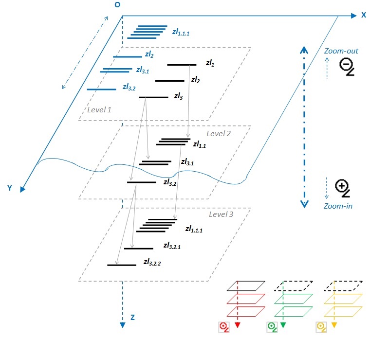
2. Z-text model. Zooming as a Multifaceted Metaphor

Steven Johnson claims that after the fixed perspective of Renaissance Art and the collages of Cubism, the “way of seeing” of our era might be called the The Long Zoom:

It is, by any measure, a difficult way of thinking, in part because our brains did not evolve tools to perceive or intuitively understand the scales of microbes or galaxies. You can catch glimpses of the long zoom in special-effects sequences, but to understand the connections between those different scales, to understand our place in the universe of the very large and the very small, you have to take another way in.  [Johnson 2006]

Johnson’s context was the world of computer games, but his observations may bring to mind Srinivas’s concept of critical hermeneutics, an attempt to reconcile interpretation and critical thinking which enables both “closeness” and “distantiation” to the object of study [Srinivas 2010, 43]. Representation at different scales together with the possibility for perspective change constitute the main elements of the zooming metaphor implemented in the z-text model and Z-editor interface, as it will be described below. While the zooming function supports bridging distant and close reading by scalable reading, the combination with contextualization on the various planes to read text and image from various perspectives agrees with notions of deep reading [Birkerts 1994], deep maps [Bodenhamer 2010], deep texts, or topic modeling of hidden texts [Blei and Lafferty 2006], and deep networks [Heuvel 2015][Heuvel forthcoming]. This combination allows for the creation of multiple levels of meaning and supports a continuous process of reinterpretation from multiple perspectives, contributing this way to recent developments of digital hermeneutic methods.
Inspired by Stephenson’s fictional primer, an interactive, scalable book that can answer the reader’s questions by continuous expansion [Stephenson 2003], the z-text model [Armaselu 2010] incorporates a multifaceted zooming metaphor.
The first facet, alluding to a primer, is actually related to the idea of exploration and learning. The content accessible at a certain moment via the interface may stimulate the reader’s curiosity and his or her desire for further discovery:

This sort of thing no longer surprised or upset Nell because it had happened hundreds of times during her relationship with the Primer. Besides, she had known, from the very first day Harv had given her the book, how the story would come out in the end. It was just that the story was anfractuous; it developed more ramifications the more closely she read it.  [Stephenson 2003, 343]

A second aspect, implied by the “anfractuous” nature of the primer, is the representation at variable scale, which can be associated, by analogy, to the iterative growing of a fractal, like in Mandelbrot’s measurement of a coastline with smaller and smaller yardsticks [Mandelbrot 1983], or to the gradual uncovering of details by zooming on an electronic map. In order to function, the metaphorical combination of learning, or being involved with the text, and zooming in the z-text model includes a layered structure [Armaselu 2014], to each layer corresponding a certain signification or symbolic meaning as compared to the whole.
Figure 1 presents a z-textual layout where units of content called z-lexias — from Barthes’s lexias, “units of reading”  [Barthes 1974, 13] — may be expanded on the deeper levels and explored by zoom-in and zoom-out. The z-lexias visible at a certain moment on the surface are disposed on different planes along with the Z-axis (hence the “z-“ prefix). The process of expanding a z-lexia is called z-writing (for instance, zl1 from level 1 is expanded to zl1.1 on level 2) and is conceived as either an addition of details to the selected content, or as a broadening in meaning according to a certain logic or argumentation strategy (simple to complex, concrete to abstract, local to global, etc.) or to a particular interpretation (as it will be shown in the following section).
Figure 1. 
Z-text layout. Levels of z-lexias (center). Changing perspective (bottom right)
The traversal of the structure to read the z-lexias and made them visible on the screen is called z-reading and supposes a back and forth movement through the layers, downward for zoom-in, upward for zoom-out. Since the conception of layers and their symbolic entailment depend on the author’s intentions and imagination, the zooming metaphor may be more or less apparent to the reader and its degree of accomplishment is determined by the inner logic driving the transition from one scale to another.
The ZoomImagine interface, Z-editor, allows both z-writing and z-reading, to each mode (expansion, zoom-in, zoom-out) corresponding a distinct hovering cursor. As illustrated in Figure 1, the metaphor of zooming is enriched by an additional facet for perspective change, represented by magnifying glasses and planes of different colors (right bottom), which may turn the representation into a multidimensional conceptual space. For example, a z-lexia on level i can be expanded on level i+1 following multiple perspectives (e.g. attached to a red, green or yellow magnifying glass), each opening a distinctive succession of layers of meaning. The magnifying glass stands therefore for a multifaceted symbol, as a tool for curiosity-driven exploration, discovery and learning by making visible what is at first hidden, and as a device providing a kaleidoscopic view on the object of inquiry.
From a technical point of view, Z-editor is a Java-based editor for documents in XML-TEI format. To each level corresponds an XML file, the ancestor-descendants relationships between z-lexias being modelled by means of a system of identifiers relating a parent on a certain level to its children on the subsequent one. There is no automatic processing for constructing the levels, the content and significance of each layer of meaning depend on the author’s ingenuity. However, the XML-TEI encoding is completely transparent to the user. Although it can be used for annotation and map-like exploration, compared with editorial platforms for annotation or for connecting maps, narratives and timelines, such as Pliny and Neatline, Z-editor is more centered on the concepts of variable scale and perspective change as organizing principles mainly of text (that can also include images). Therefore, it can be used as a tool for reading and interpretation of existing texts (and images), reconfigured along with a zoomable layout, or as an instrument supporting creative scenarios implying, for instance, the incorporation of details in a gradually expanding piece of writing in a view spotlighting the process rather than the final product. The first point (reading, interpretation and reconfiguration of content) makes the object of the present study.

3. Use cases - Theoretical and Exploratory Standpoints. Imaginary Cities in Literature and History and Historical Analysis of Town Planning

After this introduction to the z-text model underlying the ZoomImagine software (Z-editor) we will demonstrate that the zooming and contextualization features of such a tool allow creating layers of meaning that support interpretation and critical readings of literature and history. The results of three use cases will be discussed in which the Z-editor was used to explore cross-overs between text and image and history and literature in descriptions of imaginary cities and imaginary depictions of existing cities in order to establish their potential role in the history of town planning. The choice for this topic of imaginary cities in relation to town planning in literature and history makes possible to assess the potential of models like z-text for the development of digital hermeneutic methods. It also allows to use a wide array of texts and images, reading interpretations of various authors and critics from various disciplines and to compare theoretical reflections and practical applications. We claim that digital tools should be used to widen the scope of literary and historical analyses by combining multiple perspectives and not only focus on certain patterns in one dimension. For instance, the historical research of town planning in the digital era is still conditioned by morphological pattern recognition tradition that goes back to 19th century “civic art” studies such as the international renown and much translated work Der Städtebau nach seinen künstlerischen Grundsätzen of Camillo Sitte (1889) and Der Städtebau (1890) of Josef Stübben [Bohl and Lejeune 2009]. Urban morphology, practiced by 20th century in that tradition by urban historians (for instance Michael Conzen, Saverio Muratori, Lewis Mumford and Pierre Lavedan), analyzes the spatial structure of towns by focusing on patterns of streets, building blocks and lots. Some authors such as Gerard Eimer in his Die Stadtplanung in schwedischen Ostseereich (1600-1715). Mit Beiträgen zur Geschichte der Idealstadt (1961) or Bruno Fortier, La métropole imaginaire: Un atlas de Paris (1989), tried as the titles of their publications reveal to use the morphological approach to link the structure of existing towns with mappings of ideal, imaginary cities. In this morphological approach images and cartographical resources of imaginary, ideal and of existing cities are often translated into grid or radio-concentric diagrams for comparative analyses. These translations not seldom result in reduction of complexity at the cost of understanding contextual differences between these various images of cities. Such morphological readings of images and cartographic sources (and their limitations) were enhanced by the introduction of GIS in the history of town planning and architecture [Koster 2001]. However, GIS is only partially suitable for mapping literary or historical landscapes. For instance, The Mapping Lake District Literature pilot of Lancaster University makes possible to follow the trails of the authors Thomas Gray and Samuel Taylor Coleridge but the imaginary landscapes depicted in their epistolary journal and letters cannot be plotted by geographical coordinates on the map. In his exploration of the potential of spatial humanities, David Bodenhamer asks the question:

how we as humanists make GIS do what is not intended to do, namely, represent the world as culture and not simply mapped locations?  [Bodenhamer 2010, 23]

Bodenhamer proposes to create “deep maps” that contextualize GIS by combining them with multiple layers of multimedia artifacts that can be viewed separately and collectively providing various perspectives. Such multilayered multimedia objects would indeed permit to contextualize maps represented by geographical coordinates with non-geographical, spatial information. However, they do not allow to start from the other end, i.e. from non-Euclidean, topical spaces for instance, such as the imaginary cities that often inspired urban planners and architects. In this context the remarks of the author, Italo Calvino (1923-1985), of our first use case Le Città Invisibili (Invisible Cities) of 1972 are of interest. Calvino considered his Invisible Cities relevant and actual for contemporary debates on town planning:

I feel that the idea of the city which the book conjures up is not outside time; there is also (at times implicit, at other explicit) a discussion on the city in general. I have heard from a number of friends in town planning that the book touches on some of the questions that they are faced with in their work; and this is no coincidence, as the background from which the book springs is the same as theirs.  [Calvino 1983, 40]

It is this common background, a continuous space with textual and visual representations consisting of imaginary and existing cities, that we want to explore and that forms the starting point of our three cases:
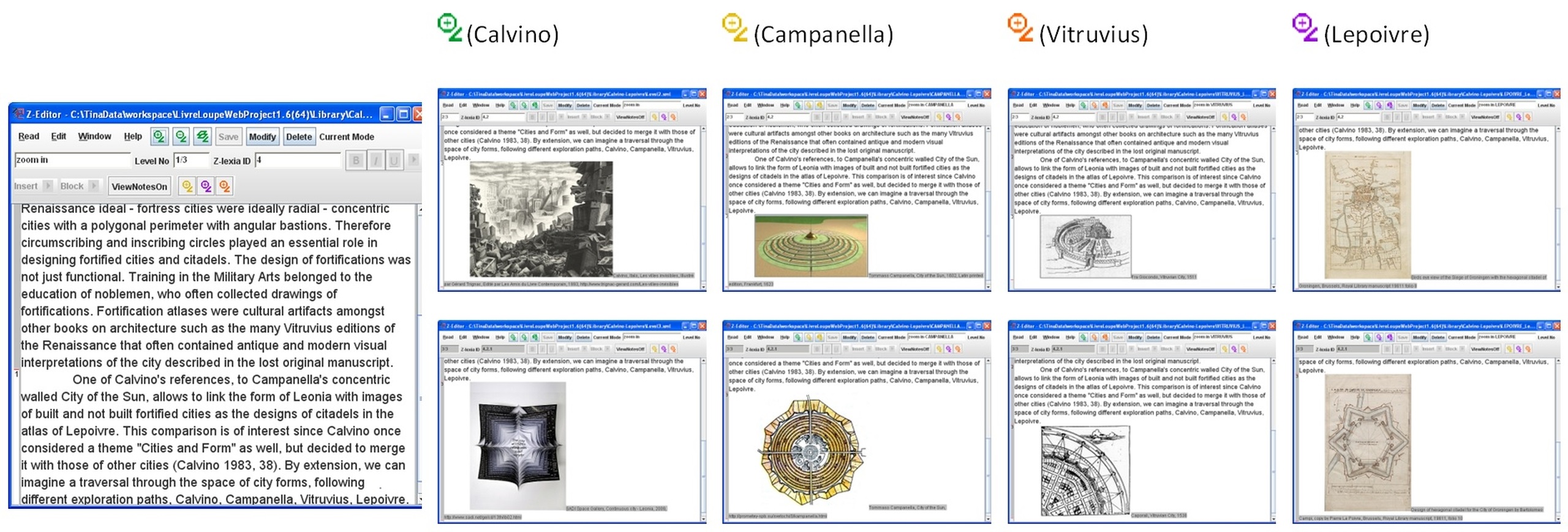
  • The first, literary case concerns readings of the Invisible Cities in which Calvino describes Marco Polo’s accounts of visits to cities to Kubla Kahn, Emperor of the Tartars. In this case, the z-text model allows zooming on imaginary spaces in this framework story and navigating in an associative way between the Invisible Cities, related publications and artistic impressions, as well as critical readings hereof.
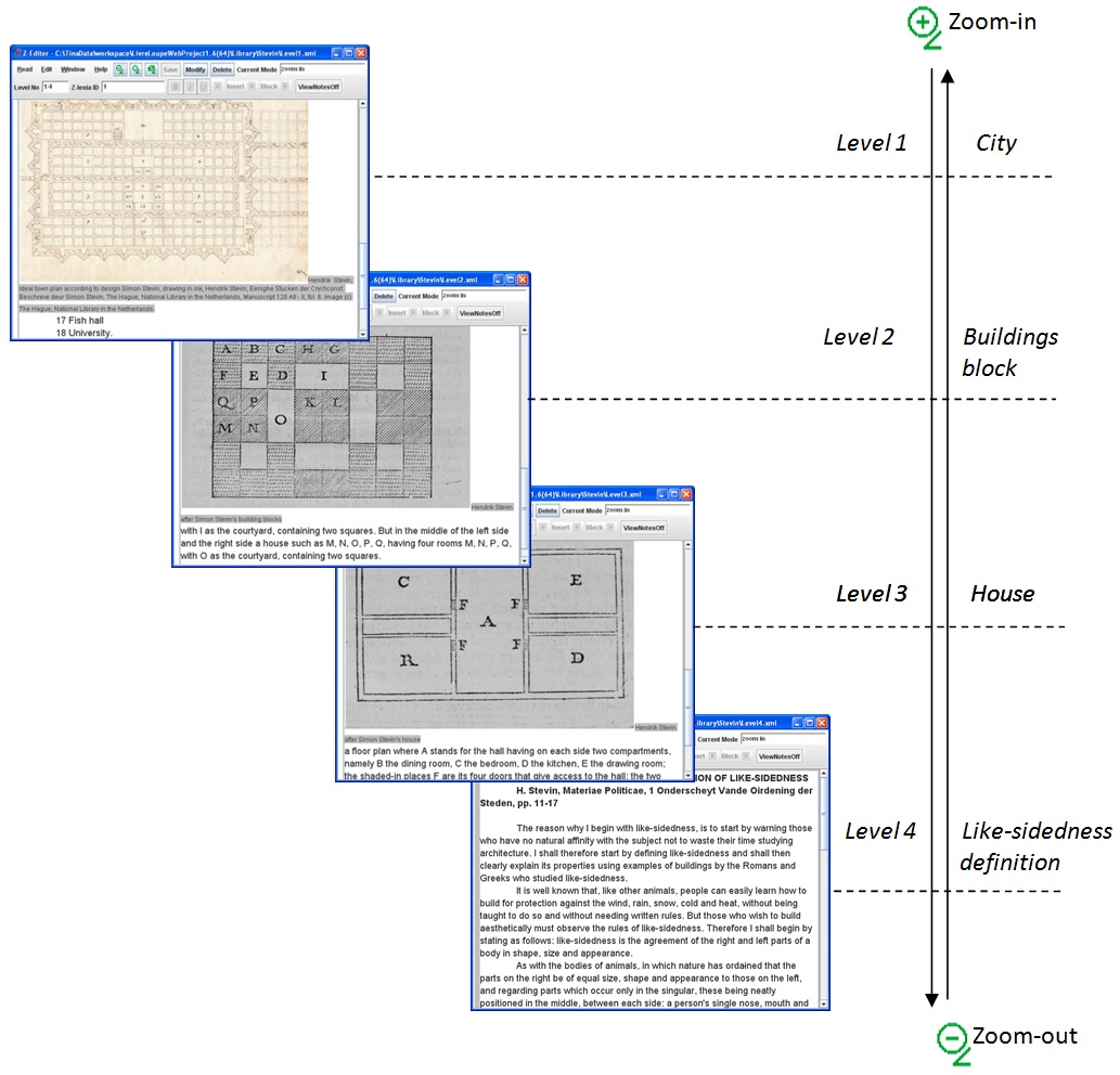
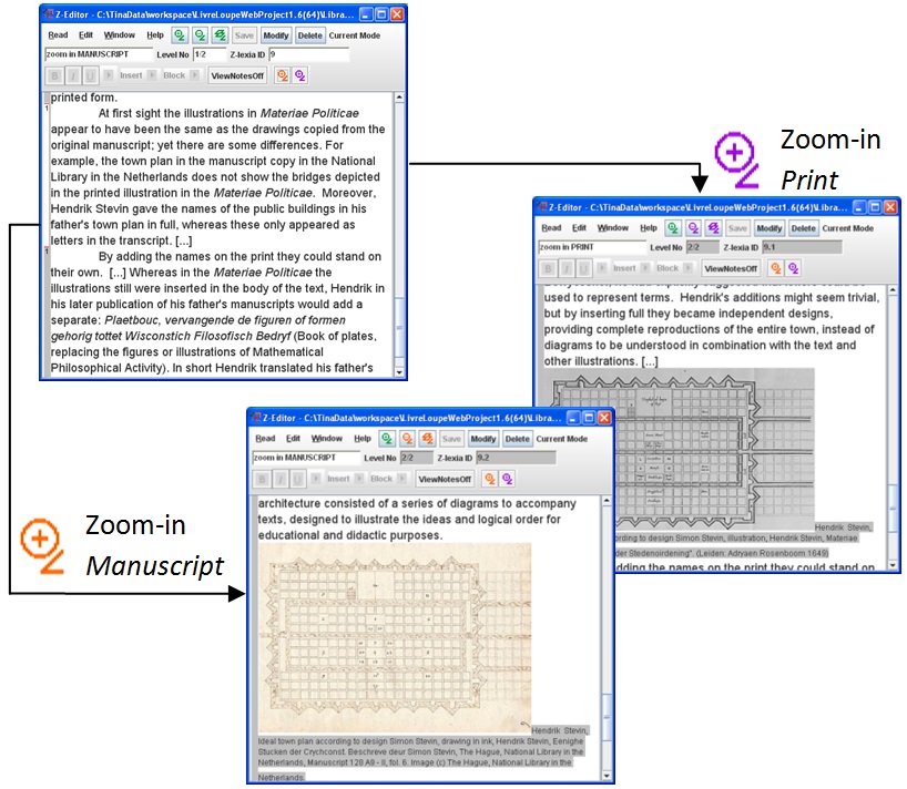
  • The zooming metaphor via Z-editor in the second, didactic case around the Dutch scholar of Flemish origin, Simon Stevin (1548-1620), teacher to Maurice, Count of Nassau, Prince of Orange (1567-1625), will demonstrate that the most common purely functional interpretations of his ideal city and houses as planning instrument for the construction of real cities are not convincing, but that these should be read in the context of didactic and educational purposes.
  • The third, historical case discusses how a z-text can be used to explore different levels of historical evidence of various imaginary depictions of existing cities. To this end, drawings of the citadel and the city of Groningen in the Netherlands in an atlas of the Flemish engineer Pierre Lepoivre (1546-1626) will be analyzed in a comparative way.

3.1. Literary Case. Invisible Cities — a "Rhizomatic" Layout inside/outside Calvino's Text

The publication of Le Città Invisibili in 1972 by Italo Calvino was directly followed by translations and comments by literary critics and by visualizations of artists inspired by the poetical descriptions of the imaginary cities in the imageless book. The division into 11 themes associated with the city that return each 5 times in the book — City and Memory, City and Desire, City and Signs, Thin Cities, Trading Cities, Cities and Eyes, Cities and Names, Cities and the Dead, Cities and the Sky, Continuous Cities and Hidden Cities — has resulted into various interpretations of these imaginary urban spaces. Kerstin Pilz uses Gilles Deleuze and Felix Guattari’s concept of rhizomatic space to underpin her argument for a postmodern reading of city descriptions [Pilz 2003], while Sambit Panigrahi underlines the importance of “cities as strata that are perennially oscillating between deterritorialisation and reterritorialisation”  [Panigrahi 2014, 26] based on concepts proposed by the same philosophers. Thus, Panigrahi compares Calvino’s description of the continuous city of Leonia that each days breaches through its boundaries of deposited waste at its circumference with Deleuze and Guattari’s explanation of a multilayered stratum that deterritorializes from a center to periphery through multiple states (epistrata) and the creation of new peripheral centres with their peripheries (parastrata).
Starting from these hypotheses, the zooming metaphor embedded in the z-text model makes possible to interpret, through rhizomatic lens, Calvino’s text itself “as strata” that can be explored by zoom-in and zoom-out. According to Deleuze and Guattari, a rhizome is made of lines of “segmentarity and stratification as its dimensions”, and lines of “flight or deterritorialization as the maximum dimension after which the multiplicity undergoes metamorphosis, changes in nature” [Deleuze and Guattari 2014, 22]. The z-text created following this interpretation implied a restructuration articulated along with different lines of stratification and flight (or metamorphosis), inside and outside Calvino’s text.
Figure 2 illustrates a reorganization of Leonia description which appeared to us as oscillating (to paraphrase Panigrahi’s analysis) around the “new-old” divide. The first level of the representation (left) contains fragments (z-lexias) mainly focusing on the concept of “new” verbalized through expressions like “refashion”, “fresh”, “brand-new”, “latest”, “up-to-date”, “new”, “renew”. The second level (right) completes the text with elements that highlight the tension between the passion and enjoyment of Leonia’s inhabitants for incessant renewal and the inevitable accumulation of old produced by it, expressed by phrases such as “remains”, “yesterday’s Leonia”, “garbage”, “expel”, “discard”, “yesterday’s existence”. Zooming-in or out to surface or hide these elements from deeper “strata”, may draw attention to the “new-old” opposition and dynamics inherent to the text. The figure shows the result of a zoom-in action, manifested by the expansion of the clicked z-lexia from the left and the retrieval of Calvino’s original fragment on the right.
Figure 2. 
Invisible Cities z-text. Zoom-in, level 1 (left), 2 (right). Stratification along with the “new-old” line.
While the “new-old” stratification determined a reconfiguration on levels inside Leonia text, further interpretation, using different “lines of flight” and changing of perspectives, implied ramifications of the z-text outside Calvino’s text. The first extension refers to visual representations, not belonging to the original work, but imagined by various artists, the second –moving on the same plane with contextual information- enables other readings of Calvino’s work, both by critics and himself. Recently, Elio Baldi focused on Calvino’s various roles in interactions between authors and critics by occasionally looking through the lens of the writer and in other moments through the eyes of the reader or editor [Baldi 2015]. Indeed, lectures by Calvino and interviews with the author reveal many shifts in perspectives on multiple planes. In a published lecture dealing with the writing of Invisible Cities, Calvino reacts to “almost all critics”, but also states “that the author’s view no longer counts” and provides interpretations “as one reader among others” [Calvino 1983, 41–42]. Calvino sometimes directly puts the Invisible Cities into context by referring to works that similarly are inspired by Marco Polo’s travels, such as the poem Kubla Kahn by Samuel Taylor Coleridge [Coleridge 1798], The Message from the Emperor by Franz Kafka of 1919 [Kafka 2012], or Il Deserto dei Tartari (The Tartar Steppe) by Dino Buzzati of 1940 [Buzzati 1986] [Calvino 1997]. On other occasions, references are indirect, for example when Calvino notes that the atlas of Kubla Kahn contains images of “lands visited in thought, but not yet discovered or founded: New Atlantis, Utopia, the City of the Sun” [Calvino 1997, 147]. On a more detailed level the possibility of sideways movements becomes important when Calvino reacts to all those critics who underlined the importance of the closing sentence by claiming that the Invisible Cities is “a many facetted book” with “various possible ‘conclusions’” [Calvino 1983, 41]. By combining the zooming functionality with the representation of visual and contextual information a z-text becomes a multidimensional space as explained below.
Figure 3. 
Invisible Cities z-text. Zoom-in, level 2 (top left), 3 (bottom left), 3,4 (top right), 5,6 (bottom right). Extension along with the “lines of flight” visual and context. [Kafka 2012] [Coleridge 1798] [Calvino 1983].[1]
Figure 3 presents an extension of a level 2 z-lexia (top left) describing Leonia’s stratified “load of refuse”, by a change of perspective (orange, VISUAL magnifying glass, bottom left) that includes an artistic illustration of the city and its mountains of leftovers (Brannigan, 2006). The same fragment can be expanded by considering a different, contextualization angle (blue, CONTEXT magnifying glass, top right), adding, for instance, on levels 3, 4 Kafka’s depiction of the imperial city “piled high with its own refuse” [Kafka 2012, 28] and the walls and towers of Coleridge’s Xanadu [Coleridge 1798]. Further contextualization on levels 5, 6 (bottom right) enriches the representation of Marco Polo’s “tales of impossible cities”, narrated to the Kahn, by Calvino’s own reflections on the “crisis of the overgrown city” and the “destruction of the natural environment”, as one of the main topics of his book [Calvino 1983, 39–41]. Since these extensions are not part of the original content (unlike the first z-text), they can be interpreted as engendered by different “lines of flight”, determining the metamorphosis of the text that becomes image or paratext.
The interface may support therefore both the reading (and restructuring) of the Invisible Cities text, according to a stratified interpretation (Figure 2), and its expansion by adding layers of related forms of expression and reflection (Figure 3). While the latter example hints to potential artistic, literary and reflective contextualizations inspired by Calvino’s comments, we may further imagine this type of gradual extension outside Invisible Cities as developed (similarly to Barthes’s analysis in S/Z) in line with different interpretative “codes” highlighting the “writability” and plurality of the text. As Calvino observes:

And yet, all these pages put together did not make a book: for a book (I think) is something which has a beginning and an end (even if it’s not a novel, in the strict sense of the word). It is a space which the reader must enter, wander round, maybe lose his way in, and eventually find an exit, or perhaps even several exits, or maybe a way of breaking out on his own.  [Calvino 1983, 38]

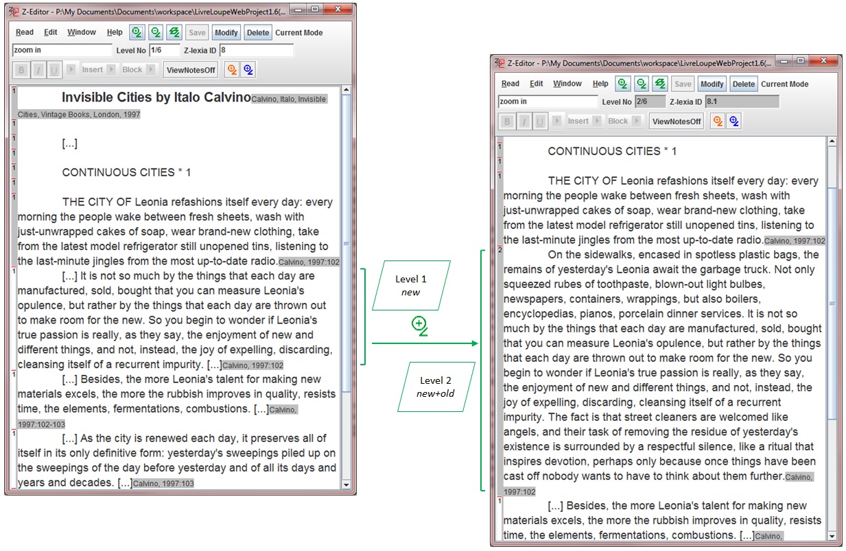
If we enter our concentric city of Leonia again immediately new associative perspectives pop up. As shown in the figure above, we recognize for instance Calvino’s reference to Kafka’s story of the Emperor’s messenger wanting to report about the death of Kubla Kahn by trying in vain to break through the walls surrounding the palace [Kafka 2012]. Nowadays, the concentric rings of garbage surrounding Leonia has also become symbolic for polluted, unlivable cities. However, another of Calvino’s references, the one to Campanella’s concentric walled “City of the Sun” allows to link the form of Leonia with images of built and not built fortified cities that are relevant to our two next cases focusing on the impact of visualizations of imaginary and existing cities for town planning, fortification and architectural design.

3.2. Didactic Case. Simon Stevin's Multilayered System Based on the Concept of "Mirror-Symmetry”

In the years 1605 and 1608, the Flemish mathematician Simon Stevin (1548-1620) published five books in two volumes with the title Wisconstighe Ghedachtenissen (Mathematical Memoirs) that can be seen as a compilation of his private lessons to Prince Maurice of Orange (1567-1625) on mathematics, natural sciences and military arts at the court in The Hague. In the fifth book, Van de Ghemengde Stoffen (Miscellanea), Stevin explained in a note that he had not been able to finish several treatises announced in the table of content (on Arithmetic, Book keeping, Architecture, Music Theory, Military Arts and other topics) in time for the printer and planned, therefore, to publish these at a later moment [Stevin 1605-1608, 5, 107]. By the time Stevin died in 1620, only a few fragments of these announced treatises had appeared in other publications.
This case discusses interpretations on Stevin’s uncompleted treatise on town planning and architecture of which fragments were adapted and published posthumously by his son Hendrik Stevin in his Materiae Politicae Burgherlicke Stoffen (Political Matters Civic Affairs) (1649) and Wisconstich Filosofisch Bedryf (Mathematical-Philosophical Act) (1667). Charles van den Heuvel made a reconstruction of Stevin’s treatise on town planning and architecture, De Huysbou, on the basis of excerpts in manuscripts of scholars such as Isaac Beeckman, Constantijn and Christiaan Huygens and Hendrik Stevin that circulated in the Dutch Republic [Heuvel 2005]. Stevin’s diagrams of ideal buildings and town known via the publication in Hendrik Stevin’s Materiae Politicae have been often described in purely morphological and rational terms [Eimer 1961] [Hoeven and Louwe 1985] [Oers 2000]. However, we will try to reveal, via the zooming features of the Z-editor interface, that Stevin’s city architecture was not conceived as one rational whole, but rather should be read from a didactic perspective to explain a multi-layered model of an ideal city and houses all based on the same underlying concept of mirror-symmetry. Nowadays we are familiar with the concept of mirror-symmetry, but at the time that Stevin wrote his treatise authors on architecture used the term ‘symmetria’ in the Vitruvian tradition i.e. as the harmonious ratio of the parts to the whole. For that reason Stevin introduced the neologism: “lycksijdcheyt”, literally like-sidedness. For Stevin, this distinction was not trivial. But in his view, mirror-symmetry had its origins in nature, unlike the proportional symmetry of Vitruvius and his followers, and should therefore serve as the basis for logical architecture:

[...] a building should be like an animal, and if one wishes to make it correctly, one should follow nature. By which it should be understood that just as nature or the Creator of animals produces like-sidedness, so the architect should emulate this and design buildings with like-sidedness.  [Stevin 1649, 13] (transl.  [Heuvel 2005, 1]).

The zooming and contextualization features of the Z-editor (Figure 4) allow us to demonstrate why the relationships between Stevin’s town and houses should be understood in the context of his didactic explanation of the underlying principle of mirror-symmetry rather by the rational arguments based on morphological correspondences between some (but not all) of the buildings blocks of houses and the town. A closer look at Stevin’s town plan reveals that most, but not all features can be explained rationally. The rectangular ground plan with its square buildings blocks enables an efficient distribution of houses and can be therefore read from a civic planning perspective as rational. However, the bastions with acute pointed faces and the odd double flanks from the bastions adjacent to the corner bastions are compromises from a military point of view. Stevin was well aware of that. In his treatise on fortification, De Sterctenbouwing [Stevin 1594], Stevin explained that the optimal form for a large city to defend itself would be a hexagon. A comparison on level 1 (city) shows indeed that the hexagonal perimeter of the fortress city results in bastions with more obtuse points that are less vulnerable for collision after a heavy impact of gunfire. Also zooming reveals that Stevin’s city cannot be read as one coherent whole. Hoeven/Louwen represented Stevin’s city as a system of building components that could be pieced together [Hoeven and Louwe 1985]. However, if we zoom-in to 2nd level, that represents buildings blocks containing different numbers of houses, it becomes clear that as a result of the variations in their rectangular form they would not all fit into the square buildings blocks represented in the town plan. Despite their differences, the blocks have in common that they are organized in such a way that all houses receive as much light as possible from the inner courts and that the rules of mirror-symmetry are always respected. In short, Stevin was not interested in forms of towns and dwellings in which contrasting demands of military, economic or social orders were planned as one whole. Instead, Stevin’s writings on the layout of houses and towns are characterized by the separation of different levels and the segregation of adjacent functions. Stevin’s synthesis of houses into blocks, blocks into towns and the ordering of urban extensions focused more on the organizational method than on the precise form. And this method was governed by a single principle: that of mirror-symmetry, to which all other organizational forms were subordinated. The reason why Stevin’s city has been read by many authors as one systematic whole might have been enhanced by their use of its representation in print in the work of Hendrik Stevin. Hendrik Stevin represented his father’s city with all the names of the civic functions: palace, churches, markets, university etc. engraved in the image itself. This way, the image of the city could be read independently as one whole. However, Hendrik Stevin’s excerpt in the manuscript version of the Huysbou, drawn after the original drawings, reveals that his father’s representation of the town, buildings blocks and separated houses consists of a series of diagrams (including letters/numbers referred to in the descriptions) that can only be understood in combination with the text and other illustrations.
Figure 4 and 5 present two z-texts. Figure 4 denotes a transposition of Stevin’s drawings and texts allowing the reader to traverse the conceptual space by zooming-in and out through the city, buildings block and house, down to the very definition of “like-sidedness”. This traversal corresponds to a change of scale in the representation of the city and its parts correlated with a didactic argumentation lead by the principle of mirror-symmetry inspired by Stevin’s text itself.
Figure 4. 
Stevin z-texts: mirror-symmetry (top right) (Stevin 1649)[2]
Figure 5. 
Stevin z-texts: contextualisation Print/Manuscript (bottom left) [Heuvel 2017][3]
The second z-text in Figure 5 illustrates zooming with perspective change (PRINT/MANUSCRIPT) in a contextualisation text [Heuvel 2017] that explains the differences between the manuscript and the printed version, determined by Hendrik’s changes in his father’s representation of the town.
Zooming provides therefore a figurative way of unfolding our contextualization and interpretation of Stevin’s multi-layered model that allowed him, in his role of private tutor, to explain the principles and natural logic of his architecture and town planning on each level, most clearly for educational and pedagogic purposes. Logical and lucid models - albeit incomplete - were for Stevin a more appropriate means of achieving that goal than a complete reproduction of reality that, with all its contradictions, might obscure the problem, or to say it in Simon Stevin’s own words in his work on fortification “because the teaching should not be complicated by arguments”  [Heuvel 2005, 68].

3.3. Historical Case. Multiple Levels of Historical Evidence in Lepoivre Atlas

Stevin was not only the tutor, but also a military advisor to Prince Maurice and accompanied him on all his campaigns in the first decades of the Eighty Years War in the Low Countries against Spain. Although Prince Maurice became Captain General of the Army and Admiral of the Fleet after the assassination of his father William the Silent in 1584 when he was 18 years old, his inexperience was not the only reason that his uncles insisted on training him in the military arts. Training in the military arts made part of the education of noblemen where elementary of warfare and fortification were taught along dancing, singing, playing music, drawing, fencing and of course disciplines such as mathematics, physics, logic, rhetoric, and languages. On the ceiling of the Palazzo dei Cinquecento in Florence, Archduke Cosimo I dei Medici is depicted drawing a fortress with a compass in his hand and Stevin explained how Prince Maurice developed an instrument in order to learn to draw fortifications in the correct way. Knowledge of fortification drawings belonged to the cultural education of noblemen and designs that once played a role in the practice of building defenses for cities ended up in their collections. Often they were re-used or adapted for decorations of fortified cities on the walls of their palaces or to create beautiful atlases. It is in this context that the atlas presented in 1624 by the Flemish engineer Pierre Lepoivre (ca. 1546 – 1627) to the archdukes Albert VI and Isabel of Austria, sovereigns of the Habsburg Netherlands must be understood [Heuvel 1998]. At first sight, “Les Plans des Villes des Païs de Hennault, d’Artois, de Breband très noblement descripts à la plume”, drawn by Lepoivre between 1615-1622, seem to provide trustworthy depictions of historical battles and sieges that took place in the Eighty Years War in the Low Countries. A closer reading of the drawings however, reveals that Lepoivre mixed his own mappings of historical events with interpretations of other cartographical depictions of besieged towns and unexecuted designs of cities, resulting in different levels of reliability and trustworthiness. This becomes clear for instance in four drawings in his atlas based on designs that the Italian engineer Bartolomeo Campi (?-1573) made for the city and citadel of Groningen in the Netherlands. The detail of the bastion was probably directly copied after Campi’s design of 1570 [Heuvel 1994]. Lepoivre included a drawing after Campi’s design for a hexagonal citadel, – similar to Stevin’s fortress city in the form of hexagon- but a pentagonal one was executed. The third drawing shows Groningen with the hexagonal citadel that never existed in that form and the fourth as a part of the Siege of Groningen in 1594, when the citadel that existed was already dismantled [Heuvel 1998].
The Z-editor not only allows moving along the four different levels of historical evidence, but also to position these drawings between more and less imaginary depictions of existing cities.
Figure 6. 
Lepoivre Atlas z-text. Zoom-out (level 4 to 1), zoom-in (level 1 to 4) and perspective change (Agustino-Campi, level 2; Aleotti-Campi, level 3). Interpretation according to the degree of reliability of the drawings as historical evidence (bottom left).[4]
In Figure 6, the explanatory texts and drawings from Lepoivre Atlas are structured on four levels corresponding to different illustrations of the city of Groningen (bird eye view, plan with the hexagonal citadel, the hexagonal citadel itself, detail of the bastion) that can be traversed by zooming-in (right to left) and zooming-out (left to right). Two alternative views (outline with pentagonal citadel and pentagonal citadel alone) are also provided on level 2 and 3 via perspective change (AGUSTINO-CAMPI, ALEOTTI-CAMPI). As the symbolic representation (bottom left) suggests, the z-text allows the reader not only to explore the projection of the city at different scales but also to understand Lepoivre drawings in a larger context based on the degree of reliability of historical evidence, as further explained below.
Pierre Lepoivre had assisted in the execution of the citadel of Groningen and must therefore have known which designs of Campi had been approved for execution [Martens 2014]. Nowadays, we would call Lepoivre’s variations on Campi’s non executed designs historical falsifications, however at the time of Lepoivre the mixing of sources to illuminate historic events that took place apparently was not considered to be problematic. Not only Lepoivre knew also the archdukes in their official role of sovereigns of the Habsburg Netherlands must have known. They had given Lepoivre official commission to make designs for reliable fortification works and given him 500 Flemish pounds for the atlas, but seem to have had no objection that the engineer selected or at least included drawings based on non-executed designs or adaptations of representations of historical events. The re-use in Lepoivre’s atlas of the designs of Campi originally intended to explain technical details and to support administrators in their decision to approve or disapprove the execution hereof gave them an additional cultural meaning as objects of prestige or study in the private collection of the archdukes.
Such multiple layers of meaning cannot be grasped in full by GIS or existing spatial digital humanities software, but that requires tools such as Z-editor for scalable readings and moving through geographical and topical spaces.
Finally, we may picture ourselves navigating in an associative way through imaginary cities whose features might have inspired both Calvino's literary writings as Lepoivre's designs. Contemporary artists still inspired by Calvino seem to delve into a collective visual memory of “cities”, in a way Renaissance engineers linked their designs to representations of ideal cities and new fortress towns, from Campanella's City of the Sun to Zamosz in Poland. Renaissance ideal fortress cities were radial concentric cities with a polygonal perimeter with angular bastions. Therefore circumscribing and inscribing circles played an essential role in designing fortified cities and citadels. The design of fortifications was not just functional. Training in the Military Arts belonged to the education of noblemen, who often collected drawings of fortifications. Fortification atlases were cultural artifacts amongst other books on architecture such as the many Vitruvius editions of the Renaissance that often contained antique and modern visual interpretations of the city described in the lost original manuscript.
One of Calvino's references to Campanella's concentric walled City of the Sun allows to link the form of Leonia with images of built and not built fortified cities as the designs of citadels in the atlas of Lepoivre. This comparison is of interest since Calvino once considered a theme “Cities and Form” as well, but decided to merge it with those of other cities [Calvino 1983, 38]. By extension, we can imagine a traversal through the space of city forms, following multiple exploration paths and connecting imaginary cities in literature (Calvino, Campanella) and in architectural treatises and theory (Vitruvius) with imaginary representations of existing cities in design (Lepoivre).
Figure 7. 
Imaginary Cities z-text. Level 1 (left), 2 (top right), 3 (bottom right). Traversal through the space of forms, Calvino, Campanella, Vitruvius, Lepoivre.[5]
The examples presented in this section were intended to illustrate how the reconfiguration, restructuring, reorganization of existing content (excerpts from books, articles, essays, etc., images) may be shaped via metaphoric and digital lens, both in the interpretation and the production of knowledge. Our assumption was that the interface mediates a two-stage process, by influencing our perception of a topic, as well as the way we represent this perception via the interface. In our cases, the metaphor of zooming determined a certain predisposition to discern different scales, angles, associations and layers of meaning in the material of study and, at the same time, allowed remodeling (and ultimately rereading) the matter in a digital form consistent with that metaphor. A phenomenon worthy of further inquiry.

4. Conclusions and Future Work

In the introduction we stated that metaphors embedded in the interface may support and shape interpretation. It is what we tried to demonstrate navigating through the three use cases for literary, didactic and historical representations of imaginary and existing cities and the corresponding z-texts built via the Z-editor, an interface for writing and reading zoomable texts.
The first case proposed a stratification of textual and visual details, made visible or invisible through the change of scale and perspective, which allowed a critical projection of Calvino’s Invisible Cities onto a “rhizomatic” interpretative space. In the second example, we transposed Stevin’s conceptual system of town design into a scalable structure, from the level of the whole city to that of a house, to the abstract layer explaining the concept of mirror-symmetry and its role as an organizing principle within the whole system interpreted in this way from a didactic viewpoint. An additional z-text illustrated the contextualization of Stevin’s work by highlighting, via the switch of perspective from manuscript to print, the differences in the visual-textual dynamics in Simon’s versus Hendrik’s representations of the town plans. The third experiment dealt with a symbolic traversal at variable scale of the city of Groningen drawings from Lepoivre Atlas which together with views of alternative designs assisted interpretation within the larger context of more or less reliable historical evidence.
As Eberhardt affirms referring to Gadamer’s hermeneutics, the use of zooming not only provides more detail but also allows horizontal expansion, resulting in widening horizons [Eberhardt 2004, 87–88]. The study of the role of zooming in particular, and of metaphors in general, in digital hermeneutics has, in our opinion, the potential for widening horizons, both in terms of interpretation and of production of knowledge. Further experiments and features development should be envisaged (e.g., allowing the users to have an overview, reconstruct and annotate the steps they took while navigating in the interpretative space provided by the digital tool and the implied metaphor). Moreover, further requirements can be explored by interdisciplinary research and training programs, like the Digital History and Hermeneutics Doctoral Training Unit, starting in 2017 at the University of Luxembourg, intended to create a “space of experiment” and to encourage “critical and self-reflexive use of digital tools and technologies” [Fickers 2016], in order to stimulate creative thinking and to improve the exploitation of these tools and technologies for research and teaching. In this context, the combined analysis of metaphor and digital hermeneutics may open new paths for experiment and reflection in Digital Humanities.

Notes

[1]  Brannigan, Colleen Corradi, (2006) Oil and acrylic paintings, Le Città Invisibili, Leonia, http://www.cittainvisibili.com/en/portfolio/leonia-en.html. (with the artist's agreement) (Accessed May 22, 2017). Coleridge, Samuel Taylor (1798) “Kubla Kahn”. In The Rime of the Ancient Mariner and Other Poems, New York: Dover Publications Inc. Illustration Patten Wilson, http://www.fulltable.com/vts/aoi/w/wilson/07.jpg. (Accessed May 22, 2017).
[2]  Hendrik Stevin, Ideal town plan according to design Simon Stevin, drawing in ink, Hendrik Stevin, Eenighe Stucken der Crychconst. Beschreve deur Simon Stevin, The Hague, KB National Library of the Netherlands, Manuscript 128 A9 - II, fol. 6. Image (c) The Hague, KB National Library of the Netherlands. Hendrik Stevin, after Simon Stevin's buildings block, illustration, Hendrik Stevin, Materiae Politicae, “Byvough der Stedenoirdening”. (Leiden: Adryaen Rosenboom 1649). Hendrik Stevin, after Simon Stevin's house, illustration, Hendrik Stevin, Materiae Politicae, “Byvough der Stedenoirdening”. (Leiden: Adryaen Rosenboom 1649). Hendrik Stevin, Ideal town plan according to design Simon Stevin, illustration, Hendrik Stevin, Materiae Politicae, “Byvough der Stedenoirdening”. (Leiden: Adryaen Rosenboom 1649).
[3]  Hendrik Stevin, Ideal town plan according to design Simon Stevin, drawing in ink, Hendrik Stevin, Eenighe Stucken der Crychconst. Beschreve deur Simon Stevin, The Hague, KB National Library of the Netherlands, Manuscript 128 A9 - II, fol. 6. Image (c) The Hague, KB National Library of the Netherlands. Hendrik Stevin, after Simon Stevin's buildings block, illustration, Hendrik Stevin, Materiae Politicae, “Byvough der Stedenoirdening”. (Leiden: Adryaen Rosenboom 1649). Hendrik Stevin, after Simon Stevin's house, illustration, Hendrik Stevin, Materiae Politicae, “Byvough der Stedenoirdening”. (Leiden: Adryaen Rosenboom 1649). Hendrik Stevin, Ideal town plan according to design Simon Stevin, illustration, Hendrik Stevin, Materiae Politicae, “Byvough der Stedenoirdening”. (Leiden: Adryaen Rosenboom 1649).
[4]  Birds eye view of the Siege of Groningen with the hexagonal citadel of Groningen, Brussels, Royal Library manuscript 19611 folio 8: “Groninghen Assiegee”. Plan of the city of Groningen and the hexagonal citadel of Bartolomeo Campi, Brussels, Royal Library manuscript 19611 folio 11, Subscription: “Des trouble du Pais Bas qui sont amines l’an 1566 DU PLAN DE GRONINGE ET DU, Chasteauquy fut batie par ordre de Sr. don Fernande D’Alvarez l’an 1569”, 6 March 1618.Design of hexagonal citadel for the City of Groningen by Bartolomeo Campi copy by Pierre Le Poivre, Brussels, Royal Library manuscript 19611 folio 10: “LA PLAN DU CHASTEAU DE GRONINGEN, qui fut batit l’an 1570 par advis du Duc Alvaqui fut ordonéz de l’ingenieur Pacciotto […] fut achevé de Bartholomeo Campy, P. Lepoivre 12 April 1618.” Design of Bastion for the City of Groningen, plan top level and fundaments level by Bartolomeo Campi, copy by Pierre LePoivre for his atlas, Brussels, Royal Library manuscript 19611 folio 13, Subscription: [top] “Particuliarités des fondements [sic:fundaments] de l’architecture du chasteau de gruningen [Groningen] qui fut comenses [sic: commencés] de l’ingenieur pachote [sic: Francesco Paciotto], et depuis fur achevé du Sr. Capitano Bertholmeo Campy [Bartolomeo Campi] Ingenieur de Sa Majestà et l’autheur de ces oeuvres à diondante des dict Ingenieur. Ceste scale contient 300 piedz depuis la letter A et B faicte à Bruxelle le 19 April 1618 P. Lepoivre architecte de Sa Majesté Catholique”. Subscription: [bottom] “Particularités du boulverts y cy dessus remarqués par la Plan figure de la letter” etc. Pentagonal citadel of Groningen executed after design of Bartolomeo Campi, copy by Giambattista Aleotti, Ferrara, Biblioteca Comunale Aristostea. Man. Classe I 763 n. 138. Outlines for the pentagonal citadel of Groningen by Capitano Agustino with the accepted changes proposed by Bartolomeo Campi, Archivo General de Simancas, Mapas, Planos y Dibujos VII-48. Dotted lines in red show accepted proposal of Bartolomeo Campi for the measurements of the pentagonal citadel Groningen.
[5]  Calvino, Italo, Les villes invisibles, Illustré par Gérard Trignac, Edité par Les Amis du Livre Contemporain, 1993, http://www.trignac-gerard.com/Les-villes-invisibles. (Accessed May 22, 2017). SADI Space Gallery, Continuous city - Leonia, 2009, http://www.sadi.net/ge/cd/13th/lb02.html. (Accessed May 22, 2017). Campanella, Tommaso, City of the Sun, 1602, Latin printed edition, Frankfurt, 1623. Campanella, Tommaso, City of the Sun, http://prometey-spb.su/svetochi/0/kampanella.html. (Accessed May 22, 2017). Fra Giocondo, Vitruvian City, 1511. Caporali, Vitruvian City, 1536. Birds eye view of the Siege of Groningen with the hexagonal citadel of Groningen, Brussels, Royal Library manuscript 19611 folio 8: “Groninghen Assiegee”. Design of hexagonal citadel for the City of Groningen by Bartolomeo Campi copy by Pierre Le Poivre, Brussels, Royal Library manuscript 19611 folio 10: “LA PLAN DU CHASTEAU DE GRONINGEN, qui fut batit l’an 1570 par advis du Duc Alvaqui fut ordonéz de l’ingenieur Pacciotto […] fut achevé de bartholomeo Campy, P. Lepoivre 12 April 1618”.

Works Cited

Akker et al 2011 Akker, Chiel van den, et altri (2011) “Agora Digital Hermeneutics: Online Understanding of Cultural Heritage”. Proceedings of the 3rd International Conference on Web Science (WebSci’11). Koblenz, Germany, 14 – 17 June 2011.
Armaselu 2010 Armaselu (Vasilescu), Florentina (2010) Ph.D. thesis, Le livre sous la loupe : Nouvelles formes d'écriture électronique, Papyrus, University of Montreal Institutional Repository. https://papyrus.bib.umontreal.ca/xmlui/handle/1866/3964. (Accessed May 22, 2017).
Armaselu 2014 Armaselu, Florentina (2014) “The Layered Text. From Textual Zoom, Text Network Analysis and Text Summarisation to a Layered Interpretation of Meaning”. Digital Humanities 2014 Conference Abstract EPFL-UNIL, Lausanne, Switzerland, 8-12 July 2014, 79-82. http://dharchive.org/paper/DH2014/Paper-515.xml. (Accessed May 22, 2017).
Baldi 2015 Baldi, Elio (2015) “l’ochiochescrive. La dinamica dell’imagine autoriale di Calvino nellacriticaitaliana”, Incontri Anno 30, 2015 fascicolo 1, p. 22-33- www.rivista-incontri.nl. (Accessed May 22, 2017).
Barr 2003 Barr, Pippin (2003) User-Interface Metaphors in Theory and Practice, A thesis submitted to Victoria University of Wellington in fulfilment of the requirements for the degree of Master of Science in Computer Science. http://www.pippinbarr.com/academic/Pippin_Barr_MSc_Thesis.pdf. (Accessed May 22, 2017).
Barthes 1974 Barthes, Roland (1974) S/Z, first edition 1970, translated by Richard Miller, Hill and Wang, New York.
Birkerts 1994 Birkerts, Sven (1994) The Gutenberg Elegies: the Fate of Reading in an Electronic Age, Faber & Faber, Boston (MA).
Blei and Lafferty 2006 Blei, David M. Lafferty, John D. (2006) “Dynamic Topic Models”, In Proceedings of the 23rd international Conference on Machine Learning. ICML '06, pp. 113-120.
Bodenhamer 2010 Bodenhamer, David (2010) “The Potential of Spatial Humanities” In The Spatial Humanities: GIS and the Future of Humanities Scholarship edited by David J. Bodenhamer, John Corrigan and Trevor M. Harris, Indiana University Press, Bloomington, 14-30.
Bohl and Lejeune 2009 Bohl, Charles. Lejeune, Jean Francois (eds.) (2009) Sitte, Hegemann and the metropolis: modern civic art and international exchanges, Routledge, London, New York.
Buzzati 1986 Buzzati, Dino (1986) Il Deserto dei Tartari, Mondari, Milan (Org. 1940).
Calvino 1972 Calvino, Italo (1972) Le città invisibili, Einaudi, Turin.
Calvino 1983 Calvino, Italo (1983) “Italo Calvino on ‘Invisible Cities’” Columbia: A Journal of Literature and Art, No. 8, Spring/Summer 1983, 7-42 http://www.jstor.org/stable/41806854. (Accessed May 22, 2017).
Calvino 1997 Calvino, Italo (1997) Invisible Cities. Translated from the Italian by William Weaver, Vintage Books, London.
Capurro 2010 Capurro, Rafael. (2010) “Digital Hermeneutics: An Outline”. In AI & Society 25(1): 35–42. http://www.capurro.de/digitalhermeneutics.html. DOI: 10.1007/s00146-009-0255-9. (Accessed May 22, 2017).
Colburn and Shute 2008 Colburn, Timothy R. Shute, Gary M. (2008) “Metaphor in computer science”. In Journal of Applied Logic, Volume 6, Issue 4, December 2008, Pages 526–533. http://www.sciencedirect.com/science/article/pii/S1570868308000463. (Accessed May 22, 2017).
Coleridge 1798 Coleridge, Samuel Taylor (1798) “Kubla Kahn”. In The Rime of the Ancient Mariner and Other Poems, Dover Publications Inc., New York.
Deleuze and Guattari 2014 Deleuze, Gilles. Guattari, Félix (2014) A Thousand Plateaus: Capitalism and Schizophrenia, Bloomsbury Academic, London, New Delhi, New York, Sydney, paperback 2013, reprinted 2014.
Eberhardt 2004 Eberhardt, Philippe (2004) The Middle Voice in Gadamer’s Hermeneutics: A basic interpretation with some Theological Implications, Mohr Siebeck, Tübingen.
Eimer 1961 Eimer, Gerhard (1961) Die Stadtplanung in schwedischen Ostseereich, 1600-1715. Mit Beitr ägenzur Geschichte der Idealstadt, Svenskabokförlaget, Stockholm.
Fickers 2016 Fickers, Andreas e.a. (2016) PRIDE Doctoral Training Unit (DTU) on “Digital History & Hermeneutics”. http://www.dhlab.lu/digital-literacy/digital-history-hermeneutics-dtu/. (Accessed May 22, 2017).
Gualeni 2015 Gualeni, Stefano (2015) Virtual Worlds as Philosophical Tools: How to Philosophize with a Digital Hammer, Palgrave Macmillan, 194 pp., ISBN: 978-1137521774.
Halskov Masden 1996 Halskov Madsen, Kim (1996) “A Guide to Metaphorical Design”, In METAFORERI SPROG OG TÆNKNING, Proceedings fra Metafornetværketsseminari Odense den 8.-10. februar 1996. http://www.sprog.asb.dk/cg/metaphor/tekst/1/HALSKOV.HTM. (Accessed May 22, 2017).
Heuvel 1994 Heuvel, Charles van den (1994) “Bartolomeo Campi successor to Francesco Paciotto. A different method of designing citadels: Groningen and Flushing”. In Architetti e ingegneri militari italiani all'estero dal XV al XVIII secolo, Sillabe, Livorno-Roma, 153-167.
Heuvel 1998 Heuvel, Charles van den (1998) “Pierre Le Poivre (1546-1626). Engineer of the King and the Representation of Architecture”, in W. Thomas, L. Duerloo,  eds., Albrecht & Isabella. Essays, Brepols, Turnhout, 198- 202.
Heuvel 2005 Heuvel, Charles van den (2005) “De Huysbou”: A reconstruction of an unfinished treatise on architecture, townplanning and civil engineering by Simon Stevin, KNAW-Edita, Amsterdam. http://www.dwc.knaw.nl/wp-content/HSSN/2005-7-Huysbou%20Stevin.pdf. (Accessed May 22, 2017).
Heuvel 2015 Heuvel, Charles van den (2015) Mapping Knowledge Exchange in Early Modern Europe: Intellectual and Technological Geographies and Network Representations, International Journal of Humanities and Arts Computing 9.1, 95–114, DOI: 10.3366/ijhac.2015.0140.
Heuvel 2017 Heuvel, Charles van den (2017) “‘As the Author Intended’: Transformation of the Unpublished Writings and Drawings of Simon Stevin (1548-1620)”, Translating Early Modern Science,Edited by Sietske Fransen, Niall Hodson Karl A.E. Enenkel, Brill Publishers, Leiden Boston, 119-153.
Heuvel forthcoming Heuvel, Charles van den, e.a., (forthcoming) “Deep Networks as Associative Interfaces to Historical Research”, Power of Networks. Prospects of Historical Networks Research. Edited by Florian Kerschbaumer, Linda von Keyserlingk, Martin Stark, Marten Düring, Routledge, Oxford.
Hoeven and Louwe 1985 Hoeven, Casper. van der/Louwe, Jos. (1985) Amsterdam als stedelijk bouwwerk. Een morfologische analyse, Sun. Amsterdam.
Ihde 2003 Ihde, Don. (2003) “More Material Hermeneutics”. Paper presented at the meeting on “Hermeneutics and Science”, Tihany, Hungary, June 7 - 11, 2003.
Indurkhya 1992 Indurkhya, Bipin (1992) Metaphor and Cognition: An Interactionist Approach, Kluwer Academic Publishers, Dordrecht.
Johnson 2006 Johnson, Steven (2006) “The Long Zoom”, The New York Times, October 8, 2006.http://www.nytimes.com/2006/10/08/magazine/08games.html?_r=0. (Accessed May 22, 2017).
Kafka 2012 Kafka, Franz (2012) “A Message from the Emperor,” A Hunger Artist and Other Studies. A new translation by Joyce Crick, Oxford, Oxford World Classics, 28. (0rg. 1919).
Koster 2001 Koster, Elwin (2001) Stadsmorfologie: eenproeve van vormgerichtonderzzoek ten behoeve van stedenbouwhistorischonderzoek. Groningen PhD [with an English summary: (Urban morphology. A taste of a form-oriented approach to the history of urban development).
Lakoff and Johnson 2003 Lakoff, George. Johnson, Mark (2003) Metaphors we live by. The University of Chicago press, Chicago, London.
Lepoivre 1624 Lepoivre, Pierre (1624) “Les Plans des Villes des Païs de Hennault, d’Artois, de Breband, très noblemen descripts a la plume par l’architecte Pierre Le Poivre” etc., Royal Library Albert I, Brussels, Ms. 19611.
Mandelbrot 1983 Mandelbrot, Benoit B. (1983) The Fractal Geometry of Nature, W.H. Freeman and Company, New York, 1977, 1982, 1983.
Martens 2014 Martens, Pieter (2014) “Lepoivre”, In: Nationaal Biografisch Woordenboek, Vol. 21, Koninklijke Academiën van België, Brussels, kol. 656–670.
Oers 2000 Oers, Ron van (2000) Dutch Town Planning Overseas during VOC and WIC Rule (1600-1800), Walburg Pers, Zutphen.
Panigrahi 2014 Panigrahi, Sambit (2014) “Cities as Strata in Italo Calvino's Invisible Cities”, The Explicator, 72:1, 23-27, DOI: 10.1080/00144940.2013.875873.
Pilz 2003 Pilz, Kerstin (2003) “Reconceptualising Thought and Space: Labyrinths and Cities in Calvino's Fictions”, Italica, 80, 229-242. http://www.jstor.org/stable/30038769. (Accessed May 22, 2017).
Ramsay 2008 Ramsay, Stephen (2008) “Algorithmic Criticism”, In A Companion to Digital Literary Studies, ed. Susan Schreibman and Ray Siemens. Blackwell, Oxford. http://www.digitalhumanities.org/companionDLS/. (Accessed May 22, 2017).
Ricoeur 1990 Ricoeur, Paul (1990) Time and Narrative, Volume 1. The University of Chicago Press, Chicago.
Ricoeur 2003 Ricoeur, Paul (2003) The Rule of Metaphor. Routledge, London.
Rockwell and Sinclair 2016 Rockwell, Geoffrey. Sinclair, Stéfan. (2016). Hermeneutica: Computer-Assisted Interpretation in the Humanities, The MIT Press, Cambridge, London.
Romele 2016 Romele, Alberto (2016) “Toward a Digital Hermeneutics”. Techné: Research in Philosophy and Technology, Philosophy Documentation Center, 20 (1), pp.76-83. https://hal.archives-ouvertes.fr/hal-01298506/document. (Accessed May 22, 2017).
Samuels and McGann 1999 Samuels, Lisa. McGann, Jerome (1999) “Deformance and Interpretation”, New Literary History, Vol. 30, No. 1, Poetry & Poetics, Winter 1999, pp. 25-56, The Johns Hopkins University Press, Baltimore. http://www.jstor.org/stable/20057521. (Accessed May 22, 2017).
Simanowski 2010 Simanowski, Roberto (2010) “Understanding New Media Art Through Close Reading: Four Remarks on Digital Hermeneutics”, www.dichtung-digital.org/2010/simanowski.htm. (Accessed May 22, 2017).
Srinivas 2010 Srinivas, Tulasi (2010) Rethinking Globalization and Religious Pluralism through the Sathya Sai Movement, Columbia University Press, New York.
Stephenson 2003 Stephenson, Neal (2003) The Diamond Age: Or, a Young Lady’s Illustrated Primer, Bantam Books, New York, 1995, new editions 1996, 2000, 2003.
Stevin 1594 Stevin, Simon (1594) De Sterctenbouwing, beschreven door Simon Stevin van Brugge, Françoys van Ravelenghien, Leiden.
Stevin 1605-1608 Stevin, Simon (1605-1608) Wisconstighe Ghedachtenissen, inhoudende t’ghene daer hem in gheoeffent heeft den Doorluchtichsten Hooghgheboren Vorst ende Heeren, Maurits, Prince van Oraengien [...], Jan Bouwensz, Leiden.
Stevin 1649 Stevin, Hendrik (1649) Materiae Politicae Vervanghende Ghedachtenissen der Oeffeninghen des Doorluchtichsten Prince Maurits van Orangie […], Adryaan Rosenboom, Leiden.
Teleoacă 2004 Teleoacă, Anca Irinel (2004) “Computer Collocations and Computer Metaphors”, Translation Journal, Volume 8, No. 3 July 2004. http://translationjournal.net/journal/29colloc.htm. (Accessed May 22, 2017).
2017 11.3  |  XMLPDFPrint